
Glaisdale
Glaisdale
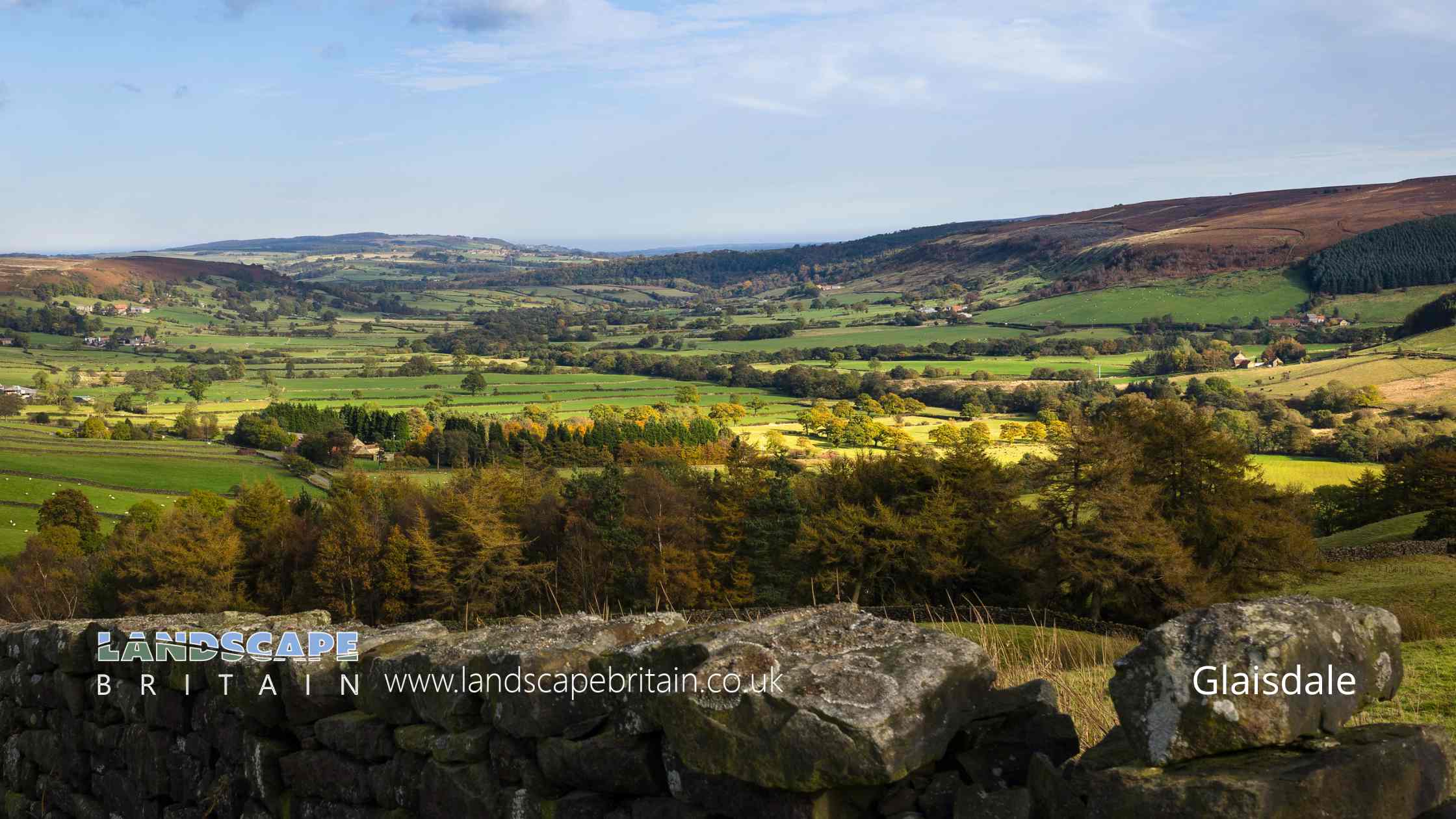
Glaisdale is in The North York Moors National Park in England.
Glaisdale is a charming village located in the North York Moors National Park in North Yorkshire, England. Nestled in a picturesque setting, it is a place steeped in history and natural beauty, making it a popular destination for visitors seeking a tranquil countryside experience.
The village’s history dates back to the Domesday Book of 1086, where it was mentioned as ‘Glasedale’. Over the centuries, Glaisdale has maintained its rural charm, with historical architecture and traditional stone-built houses adding to its character. One notable feature is the Beggar’s Bridge, an arched stone bridge built in 1619. It has a romantic legend attached to it, telling the tale of a poor lad who became a wealthy merchant and constructed the bridge to help others cross the river, reminiscent of his own struggles in youth.
Agriculture has been a mainstay of Glaisdale’s economy for centuries, with sheep farming playing a significant role. The surrounding landscapes of the North York Moors provide ideal conditions for grazing, contributing to the area’s pastoral charm. These moorlands, with their heather-covered expanses, are particularly stunning during late summer when the heather blooms, painting the hills in shades of purple and pink.
Glaisdale is also known for its warm community spirit. Annual events and gatherings, like the local agricultural show and summer fairs, bring residents and visitors together, showcasing local crafts, produce, and livestock. These events are a window into the traditional rural life of the Yorkshire Moors and offer a unique experience for those visiting the area.
For outdoor enthusiasts, Glaisdale serves as an excellent base for exploring the North York Moors. There are numerous walking trails and cycling paths that meander through the scenic moorland and woodlands. The Esk Valley Walk, for instance, passes through the village, offering walkers a chance to enjoy the tranquil beauty of the River Esk and the surrounding countryside.
Overall, Glaisdale embodies the quintessential charm of English rural life. Its combination of historical heritage, natural beauty, and a strong sense of community makes it a delightful destination for those looking to explore the Yorkshire Moors’ unique landscapes and culture.
Created: 7 January 2024 Edited: 26 March 2024
Glaisdale
Local History around Glaisdale
There are some historic monuments around including:
Round barrow on Ugthorpe Moor, 200m south west of High Park FarmRing cairn on Lealholm Moor, 640m north east of South View FarmRound cairn on Skivick Crag, 380m south west of Wheeldale LodgeRound barrow 860m south west of Dun BogsShunner Howe round barrowRoman Fort on Lease RiggRound barrow on Lealholm Rigg, 710m south west of Green Houses FarmCairns on In Moor, Struntry CarrFlat Howe round barrow 790m south east of Pannierman Bridgestone, on the eastern sidee of Glaisdale High MoorRound barrow on Thorn Hill, 310m south of the confluence of Black Dike Slack and Mardale SlackWheeldale HoweBowl barrow known as Brown Rigg Howe on Beacon Hill, Danby, together with a searchlight emplacement upon itRound barrow on Ugthorpe Moor known as Loose Howe, 130m south west of Day Well HouseWayside cross known as Stump Cross on Beacon Hill, DanbyRound barrow on Wheeldale Moor, 1150m west of Wheeldale LodgeRound barrow at Lady Cross, 730m south west of Dun BogsMiddle Rigg round barrows and segmented embanked pit alignmentThree round barrows on Waupley Moor, 775m south west of Clay Hall FarmDanby Beacon round barrowMedieval cross reused as a signpost at the top of Caper Hill on the north east side of Glaisdale High MoorPit alignment on Black Dike Moor, 800m south west of Nan StoneRound barrow on Ugthorpe Moor, 450m south west of High Park FarmThree Howes round cairnsUnenclosed hut circle settlement on Waupley Moor, 800m south west of Clay Hall FarmRound barrow on Lealholm Rigg, 690m north of Benwell HouseRawland Howe round barrow on Lealholm Moor, 450m North of South View FarmRound barrow on Wheeldale Moor, 1250m west of Wheeldale LodgeRound barrows and entrenchments on Egton High MoorLady Cross wayside cross, north of the A171 and 20m west of the Barnby turn-offEnclosure on In Moor, Struntry CarrBeggar's BridgePike Hill round cairnsBlack Hill wayside cross on Glaisdale RiggCross dyke on Glaisdale Rigg, 520m and 250m west of Highdale FarmPit alignment and two round barrows on Ugthorpe Moor, 700m south west of High Park FarmPit alignment and three round barrows on Ugthorpe Moor, 500m north east of Wood Hill HouseRound barrow 110m south west of Shunner HoweRound barrow on Lealholm Moor, 600m north east of South View FarmHart Leap cross dyke on Glaisdale Rigg, 240m and 410m north of Highdale Farm.


