
Eskdale by munki-boy
Eskdale
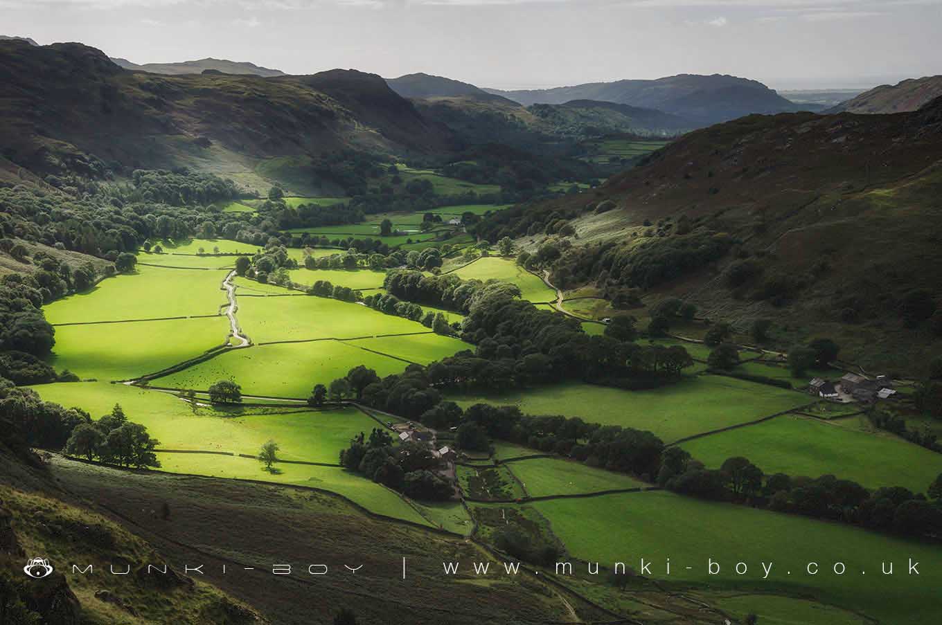
Eskdale is in The Lake District National Park in England.
Eskdale is a valley of mountains, rivers and forests in the west of the Lake District in Cumbria. Eskdale starts in the wilds of the Scafell Massif which includes England’s highest mountain, Scafell Pike and runs south west to the wide open, tidal estuary at Ravenglass.
Eskdale’s human presence can be traced back to the Mesolithic Age when hunters settled by the sea. Prehistoric sites of Neolithic and Bronze Age stone circles and settlements remains, can be seen on Boot Bank and around Devoke Water. There are also many other burial sites to be seen in the Eskdale valley. A fort was built in Roman times, high up on the mountain at Hardknott Pass. Up to five hundred cavalry would have been stationed here. There was also a fort at Ravenglass and some of the Roman remains from here now form part of the UNESCO Frontiers of the Roman Empire World Heritage Site at Hadrian’s Wall.
A narrow-gauge railway stretching from Boot to Ravenglass was built in 1875, to take iron ore away to the coast at Ravenglass and then later on was used to transport granite from Eskdale’s quarries. Today the Ravenglass and Eskdale Railway, known as La’al Ratty, is a popular tourist attraction boasting the oldest working 15” gauge locomotive in the world.
Alfred Wainwright in his guide ‘Walks from Ratty’ describes Eskdale as ‘One of the loveliest of Lakeland’s valleys. Descending from the highest and wildest mountains in the district to the Sands of Ravenglass, in a swift transition from bleak and craggy ridges to verdant woodlands and pastures, watered by a charming river’.
Created: 27 November 2016 Edited: 29 November 2023
Eskdale
Local History around Eskdale
There are some historic monuments around including:
High cross in St Paul's churchyardPrehistoric enclosure containing ten clearance cairns south west of Boat How, BurnmoorPrehistoric cairnfield 660m north east of Barnscar settlementPrehistoric cairnfield and associated field system on Waberthwaite Fell, on the north bank of Charlesground Gill, 880m south east of High CorneyPrehistoric cairnfield and enclosure 750m west of Barnscar settlementPrehistoric cairnfield, associated field system and hut circle east of Water CragPrehisitoric cairnfield 850m north west of Woodend BridgePrehistoric cairnfield on Stainton Fell, 660m north of Rowantree ForceHare Gill prehistoric cairnfield, hut circle settlement and associated field system 715m SSE of Fisher GatePrehistoric cairnfield south west of Water Crag, 290m north west of the confluence of Linbeck Gill and Devoke WaterYokerill Hows, group of seven cairnsPrehistoric cairnfield, associated field system and a funerary cairn 520m south of Barnscar settlementPrehistoric enclosure containing three hut circles and eight clearance cairns and an adjacent hut circle and cairnfield north east of Boat How, BurnmoorPrehistoric cairnfield on Waberthwaite Fell, 740m south west of Rowantree ForceSike Moss prehistoric cairnfield and two ring cairns 215m north east of Woodend BridgePrehistoric cairnfield and associated field system 350m west of The KnottPrehistoric cairnfield and associated field system on Stainton Fell, 330m south of The KnottPrehistoric cairnfield and associated field system 630m east of the confluence of Hall Beck and Devoke WaterPrehistoric cairnfield, hut circle settlement, field system, funerary cairn, and a medieval shieling on Birkby Fell west of Devoke WaterPrehistoric cairnfield on Stainton Fell, 540m south west of The KnottCairnfield including a prehistoric enclosure, 5 stone circles, 10 funerary cairns, 6 stone banks, 2 stone walls, a lynchet and a trackway on BurnmoorPrehistoric cairnfield and associated field system south west of Birkby Fell, 750m north east of The KnottPrehistoric long cairn on Stainton Fell, 940m north east of Rowantree ForceRoman kilnsPrehistoric cairnfield 570m south west of Barnscar settlementBlack Beck North prehistoric cairnfield on Birkby Fell, 950m SSW of the confluence of Linbeck Gill and Black BeckHigh cross shaft, high cross head, and high cross base in St Michael and All Angels churchyardMecklin Park cairnfield, 500m north of Ain HousePrehistoric cairnfield, field system, two funerary cairns, a Romano-British farmstead, field system and a post-medieval haematite mine at Brantrake MossPrehistoric cairnfield on Birkby Fell, 360m south east of Raven CragGray Borran group of cairnsPrehistoric round cairn on WhitfellBarnscar prehistoric cairnfield, two hut circle settlements, field systems, funerary cairns, and a Romano-British farmstead, trackway and field systemStainton Ling prehistoric hut circle settlement, associated field systems, cairnfields, funerary cairns, and a medieval field system and two shielingsCairnfield south of Straighthead Gill, BurnmoorPrehistoric cairnfield on Corney Fell, 680m north east of CharlesgroundPrehistoric cairnfield 420m south east of the triangulation pillar on Rough CragPrehistoric cairnfield on Stainton Fell, 950m north of Rowantree ForcePrehistoric stone circle, trackway, cairnfields, funerary cairns, hut circles, Romano-British farmstead and a medieval field system, 1.1km SE of StaintonPrehistoric cairnfield on Waberthwaite Fell, 840m north west of Redgill HeadPrehistoric cairnfield and associated field system north of Pike How, 650m west of High GroundPrehistoric enclosure south of The Intake, 920m south east of StaintonPike How prehistoric cairnfield and associated field system 320m south west of High GroundPrehistoric cairnfield and associated field system 800m north west and 800m north of Woodend BridgeHigh cross shaft in St John's churchyardPrehistoric cairnfield and associated field system on Stainton Fell, 760m NNE of Stainton.


