Dartmoor Ponies by Eleanor Blundell
Dartmoor
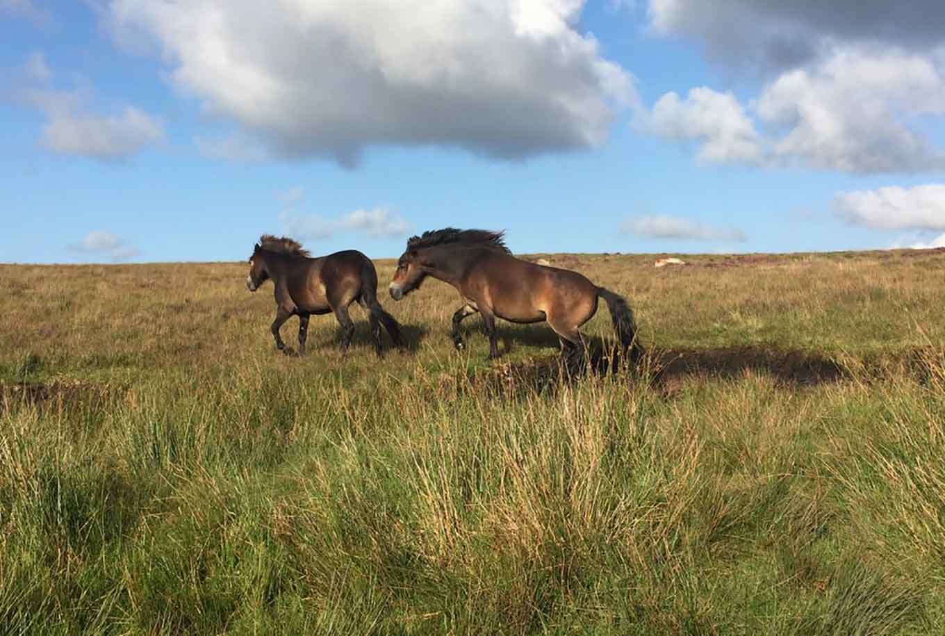
Dartmoor is in Dartmoor National Park in England.
Dartmoor National Nature Reserves
Black-a-Tor Copse (NNR)
Black-a-Tor Copse is an area of woodland, granite clitter (rocks) and moorland 380 metres above sea level. The reserve is one of Britain’s best examples of high altitude oak woodland and is nationally important for the variety of lichens and mosses that clothe the trees and rocks.
Black-a-Tor Copse is one of three high altitude woodlands on Dartmoor, offering views across the West Okement River Valley. English oak trees have grown through large granite boulders or ‘clitter’ to create a woodland which is nationally important for rare lichens and mosses.
The clean air and damp humid conditions of Dartmoor provide the perfect place for the lichens to thrive. As well as rare lichens such as Bryoria smithii, more common species including the beard lichen can also be spotted.
Twenty species of breeding birds have been recorded in the woodland and surrounding habitat, including ring ouzel and redstart.
The woodland isn’t actively managed, but light grazing by the cattle, sheep and ponies that reside on the open moorland help sustain the open character and abundant lichens and mosses. The moorland is also periodically burnt in an ancient practice known as ‘swaling’. This provides patches of more palatable grass for livestock in spring and reduces the spread of gorse and young trees.
East Dartmoor Woods and Heaths (NNR)
East Dartmoor consists of 3 joined but distinct areas: Yarner Wood, Trendlebere Down and the Bovey Valley Woodlands. Together they provide an excellent example of internationally important western oakwood with its associated bird and lower plant communities.
Look out for pied flycatchers, woodpeckers and wood warblers in the woods, Dartford warblers, ponies and fritillary butterflies around the moorland, and dippers along the River Bovey.
Wistman’s Wood (NNR)
Wistman’s Wood is a small upland oakwood in the valley of the West Dart River.
Wistman’s Wood NNR is the most famous of 3 high altitude woodland copses on Dartmoor. The wood is surrounded by granite tors and moorland and the NNR is important for the mosses and lichens found on the site’s trees and granite boulders.
The oldest trees are about 400 years old, with the woodland area doubling in size in the last 100 years.
The reserve was the site of one of the largest Bronze Age settlements in Dartmoor. The remains of almost 100 ancient buildings can be spotted.
Woodland birds such as redstart and spotted flycatcher can be seen in the wood in spring and summer, along with wheatear, stonechat and whinchat in open areas. Winter brings merlins, meadow pipits and skylarks. Short-eared owls and hen harrier can be seen on the darkest winter days.
Dendles Wood (NNR)
This is a hazardous site and for health and safety reasons public access is limited to permit holders.
Dendles Wood NNR is an area of upland oak-beech woodland located in a narrow gorge of the River Yealm. The woodland is rich in ferns, mosses and lichens.
The woodland is of particular scientific interest because it is a mixed oak-beech wood pasture which predates a large scale planting of beech in Devon in the sixteenth century. The beech is therefore assumed to be native at the edge of its natural range.
The typical damp conditions of upland Atlantic oak woods encourages a rich community of lichens and mosses. Breeding birds include redstart, wood warbler and pied flycatcher.
Seven species of bat have been found here including the nationally rare barbastelle bat which breeds here. There is a good population of the blue ground beetle which is a red data book species.
The best times to visit are from mid-April to mid-June for woodland birds and bluebells.
Created: 29 March 2021 Edited: 29 November 2023
Black-a-Tor Copse Details
Black-a-Tor Copse is a nature reserve managed by Dartmoor NNR.
East Dartmoor National Nature Reserve Details
East Dartmoor National Nature Reserve is a nature reserve managed by Natural England.
Dendles Wood Details
Dendles Wood is a nature reserve managed by Natural England.
Dartmoor
Dartmoor LiDAR Map
please wait...
Contains public sector information licensed under the Open Government Licence v3.0
Local History around Dartmoor
There are some historic monuments around including:
Partially enclosed stone hut circle settlement 350m south west of Horn's CrossBrimpts Mine, three prehistoric settlements and associated reaves 550m north west of Outer Huccaby RingTwo double stone alignments, cairn and standing stone 700m south west of Laughter Hole FarmFour stone hut circles and associated boundary walls south east of Fernworthy Reservoir, 250m north west of MetherallA stone circle, known as Fernworthy Circle, three stone alignments and five cairns 425m and 525m north west of Sandeman BridgeTwo round cairns 800m north west of Statts BridgeA partially enclosed stone hut circle settlement, two cairns containing cists and a post-medieval building 440m NNW of Powder MillsPrehistoric settlement and irregular aggregate field system 340m south west of Laughter Hole FarmFive cairns, two stone alignments and three cists, forming part of a ritual complex on Lakehead HillPartially enclosed stone hut circle settlement 420m north west and 440m west of Horn's CrossRound cairn on Soussons Down, 1.2km north west of SoussonsUnenclosed stone hut circle settlement on Tom's Hill, 870m north west of Sandeman BridgeSiward's or Nun's CrossRound cairn and Headland Warren boundary stone 210m north of Birch TorPrehistoric stone hut circle settlement 630m south of Hemstone RocksStone alignment 260m south of Higher White TorA cairn and cist 380m west and a cairn and standing stone 370m south west of Bellever Tor, forming an outlying part of a cairn cemeteryPrehistoric settlement, field system and rabbit warren south of Longaford TorThree pillow mounds adjacent to Longaford Tor forming an outlying part of a rabbit warren on the western slopes of Longaford and Littaford TorsFour round barrows on Soussons Down, 960m north west of SoussonsPartially enclosed stone hut circle settlement 900m and 940m north west of Warren House InnBeardown Man standing stoneDown Ridge stone circle and outlying standing stone 570m and 650m south of Forest InnGunpowder factory at Powder Mills, a partially enclosed stone hut circle settlement and round cairnTwo prehistoric settlements 1280m SSW of The Grey WethersRound cairn and cist on the south west side of Crow TorSix pillow mounds in Crockern Newtake forming an outlying part of a rabbit warren on the western slopes of Longaford and Littaford TorsHorn's CrossEnclosure on Cator Common, 400m ESE of Riddon BrakeFour cairns 310m south of Horn's Cross forming part of a cairn cemetery on Holne RidgeCairn on Corndon TorCairn and cist 400m east of Lydford TorDispersed stone hut circle settlement and associated fields 490m south east of Silk HouseTwo stone hut circles forming part of the enclosed stone hut circle settlement on the south-east slope of Conies Down TorPartially enclosed stone hut circle settlement known as Kraps RingStone hut circle and length of boundary walling 860m south west of Venford Reservoir damBlackaton Ball tin millFoxton CrossIrregular aggregate field system and stone hut circle 755m north east of Dunnabridge Pound FarmEnclosure east of Down Tor, 740m north east of Combshead TorRing cairn on Holne Ridge 860m north west of Hapstead Ford and 1180m north east of Ryder's HillRing cairn 296m south east of Riddon BrakeThree stone hut circles 780m SSW of Venford Reservoir damPartially enclosed stone hut circle settlement 560m west of Horn's CrossStone hut circle and associated walling 780m WNW of Longaford TorRound cairn 590m south-west of Beardown Man lying on the eastern slope of Conies Down TorCairn with cist S of Royal HillWayside cross 910m ESE of Crazy Well PoolPrehistoric enclosed settlement 740m north west of Hartland TorPrehistoric enclosed settlement known as Broadun Ring, 500m north west of Hartland TorEnclosure and fields N of Yar TorRound cairn east of Down Tor, 770m north east of Combshead TorCairn and cist 875m north west of Arch TorEnclosure and stone hut circle 535m south-west of Beardown Man forming part of the dispersed settlement on the eastern slope of Conies Down TorThree round cairns 960m and 920m north east of Outer Huccaby RingThree hut circles E of Bush DownRound cairn 480m south west of Higher White TorStone hut circle 630m south-west of Beardown Man forming part of a dispersed settlement on the eastern slope of Conies Down TorStone hut circle 215m south east of Hartland TorEnclosed stone hut circle settlement on the south-east slope of Conies Down TorHut circles SE of Yar TorBlowing house on Down RidgeEnclosure and stone hut circle 160m south east of Broad HoleKerbed cairn and cist 635m south west of The Grey WethersOuldsbroom CrossStone hut circle settlement 320m north east of CrockernWayside cross on Down Ridge 1.1km south west of Saddle BridgeA partially enclosed stone hut circle settlement 670m south of The Grey WethersKistvaen 325yds (300m) S of ArchertonBroadun prehistoric enclosed settlement, 780m NNW of ArchertonThree agglomerated enclosures containing stone hut circles, a cairn cemetery, post-medieval fields and tinworks on Chagford CommonCamp 325yds (300m) SE of ArchertonPrehistoric enclosed settlement known as Outer Huccaby Ring and associated irregular aggregate field systemStone alignment and cairn 830m east of Down TorCairn cemetery 900m north east of Hapstead Ford and 2km WSW of Fore StokeYar Tor stone row and adjacent cistPart of the Dartmeet coaxial field system and other archaeological remains on Holne Moor west and north west of Venford ReservoirMedieval farmstead and field system, post-medieval tinworks, prehistoric settlements and cairns north and west of Gibby CoombeA prehistoric settlement with enclosures, an irregular aggregate field system and cairn north of Bellever TorCist and cairn 590m SSE of Skir FordRingleshutes tinworkAn agglomerated enclosure and two stone hut circles 580m west of Laughter Hole FarmPrehistoric fields, settlements and cairn south east of Venford Reservoir forming part of the Dartmeet coaxial field systemTwo cairns on the summit of Water Hill 450m north west of Warren House InnStone hut circle 890m south-west of Beardown ManTwo stone hut circles 850m west of Siward's or Nun's Cross, forming part of an unenclosed stone hut circle settlementTwo cairns 720m and 800m east of Higher White TorHut circle and field system NW of Saddle BridgeCoaxial fields, prehistoric settlement, two cairns and a stone alignment in Little Stannon Newtake, 900m south east of Stannon TorTinners' building in Great Stannon Newtake, 810m north west of Stannon TorHut circle 150yds (140m) NE of Moorlands FarmTwo stone hut circles 810m west of Siward's or Nun's Cross forming part of an unenclosed stone hut circle settlementCairn on Hurston Ridge 1km north west of Warren House InnRound cairn 400m south east of Higher White TorTinworks, field systems, settlements, warren, cairns and a stone alignment at Headland WarrenRoundy Park prehistoric enclosure and cairn with cist, 560m north east of ArchertonTwo cairns with cists E of Whiteworks tin mine buildingsAn enclosed stone hut circle settlement, round cairn, pillow mound and tinworking earthworks 820m WSW of Nun's CrossCairn S of Royal HillCairn 500m NNW of ArchertonHut circles and field system SW of Combestone WoodEight cairns forming part of a cairn cemetery on Holne Ridge and a stone alignment immediately west of Horn's CrossStone hut circle 655m south-west of Beardown Man forming part of a dispersed settlement on the eastern slope of Conies Down TorAn enclosed stone hut circle settlement 940m WSW of Nun's CrossStone hut circle 640m south-west of Beardown Man forming part of a dispersed settlement on the eastern slope of Conies Down TorEylesbarrow Tin Mine and associated remainsCross NE of Nun's CrossA ring cairn 700m south east of Runnage Bridge, on the southern side of Soussons DownRabbit warren 410m west and 310m north west of Beardown FarmEnclosure and stone hut circle 200m south of Broad HoleEnclosed prehistoric settlement 650m south west of Longaford TorMedieval settlement 470m east of HartylandTwo Headland Warren boundary stones, 275m and 430m north of Birch TorFour cairns 560m east of Hapstead Ford and 1660m east of Ryder's Hill, forming part of a cairn cemetery in the Mardle ValleyFour hut circles N of Bush DownCairn on Chagford Common 320m west of West Vitifer MineUnenclosed stone hut circle settlement, two cairns and section of field system 330m north east of Hemstone RocksBlowing house and mill at GobbetCairn and cist on Chittaford Down, 300m north of ArchertonPrehistoric settlement and irregular aggregate field system 600m west of Laughter Hole FarmWayside cross on Down Ridge 730m south west of Saddle BridgeCoaxial fields and prehistoric settlements 180m north and 350m north west of Hartland TorTwo irregular aggregate field systems with associated settlements, part of a coaxial field system, boundary stones and historic fields on Riddon RidgeCairnfield and field 1030m north west of ArchertonHuccaby RingTwo cairns on Cator CommonSettlement SE of Two Bridges, Blackbrook RiverRound cairn 580m south of Horn's Cross forming part of a cairn cemetery on Holne RidgeTwo hut circles NW of Bush DownTwo stone hut circles 675m south-west of Beardown Man forming the southern limit of a dispersed settlement on the eastern slopes of Conies Down TorSherberton stone circle 315m SSE of Little SherbertonHut 700yds (640m) NW of Sharp TorEnclosed prehistoric settlement and round cairn 880m south west of Venford Reservoir damCairnfield and enclosure 725m east of Cuckoo RockTwo cairns and a cist 300yds (270m) NW of Swincombe intakeStone cross on Ter HillTwo stone circles known as The Grey Wethers, three round cairns, two ring cairns and an oval enclosure in Great Stannon NewtakeA round cairn on White Ridge lying 570m north of the source of Stannon BrookPartially enclosed stone hut circle settlement 780m south west of MetherallQuintin's Man round cairnStone hut circle 635m south-west of Beardown Man forming part of a dispersed settlement on the eastern slope of Conies Down TorCairns N of Corndon TorClapper Bridge, PostbridgeFour cairns on Holne Lee 1140m north west of GreatcombeStone hut circle 580m south west of Statts BridgeThree agglomerated enclosures, a round cairn and part of the Stannon block field system lying within Great Stannon NewtakeTwo cairns with two cists and a stone hut circle on the east facing slope of Lakehead Hill forming part of a ritual complexStone hut circle 770m west of Siward's or Nun's Cross forming part of an unenclosed stone hut circle settlementMedieval strip field system, tinworks, part of a prehistoric settlement, a cairn and reave on Challacombe DownCairn 190m west of ArchertonTwo enclosed stone hut circle settlements 300m south of Broad HolePillow mound 670m WNW of Longaford Tor forming an outlying part of a rabbit warren on the western slopes of Longaford and Littaford TorsEnclosed stone hut circle settlement and cairn 460m north east of Rough TorHut circle 400yds (370m) SE of SwincombeBennett's Cross: a wayside cross on the south side of the B3212, 900m north east of the Warren House InnHut circle village 600yds (548m) SE of SwincombeBlowing houses at Week FordWayside cross 1120m ENE of Childe's TombStone alignment and cairn 470m east of Stannon Brook sourceEnclosed prehistoric settlement and three round cairns 870m south east of Horn's CrossStone hut circle on Down Ridge 480m south west of Saddle BridgeStone hut circle 530m south-west of Beardown Man forming part of a dispersed settlement on the eastern slope of Conies Down TorTwo prehistoric settlements and associated field systems 810m north east of Beardown FarmStone alignment, hut circle settlement, medieval long house and post-medieval farmstead at AssycombeStone alignment, cairns, enclosed prehistoric settlement and a length of reave on Hurston Ridge.


