Corfe Castle
Corfe Castle
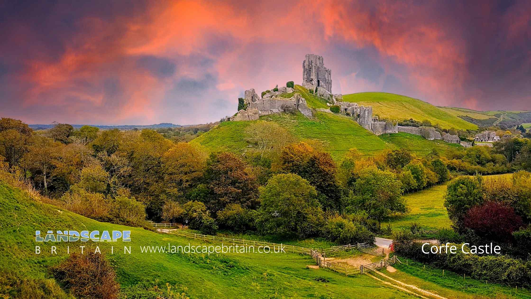
Grade I listed Corfe Castle at Wareham in Dorset is the ruins of a former royal castle, surrounded by a village of the same name. It is one of the most picturesque castles in England and has been described as “the loveliest castle in the land”.
The original structure was built by William the Conqueror, but it has been extensively added to over the centuries. The castle was besieged several times during the civil war between King Stephen and Empress Matilda, and later Between King John and rebellious barons. It finally fell to Parliamentarian troops after a three-month siege in 1646.
Today, Corfe Castle is managed by the National Trust and is open to visitors throughout the year. The village of Corfe Castle is a popular tourist destination in its own right, with many cafes, shops and pubs. There are also several walking and cycling trails in the area.
Created: 20 October 2022 Edited: 29 November 2023
Corfe Castle Details
Corfe Castle is a 62 metre high hill in Dorset.
Corfe Castle LiDAR Map

Contains public sector information licensed under the Open Government Licence v3.0
Local History around Corfe Castle
There are some historic monuments around including:
Bowl barrow 1120m WNW of Peaked Close House: part of a dispersed round barrow cemetery on Corfe CommonThe Drinking Barrow, forming part of the Grange Heath round barrow cemeteryBowl barrow 500m north east of The Drinking Barrow, forming part of the Grange Heath round barrow cemeteryBowl barrow on St Aldhelm's Head, 470m north east of St Aldhelm's ChapelBowl barrow 930m WNW of Peaked Close House: part of a dispersed round barrow cemetery on Corfe CommonThe Icen Barrow on Creech Heath, forming part of the Creech Heath round barrow cemeteryBowl barrow on Stoborough Heath 240m NNE of Hill ViewFour bowl barrows 150m north east of Seven Barrows FarmIron Age settlement and associated field system on Smedmore HillBowl barrow 200m south east of East OrchardThe Rings: a ringwork and bailey and a Civil War battery 400m south west of Corfe CastleGroup of three bowl barrows on West Hill, 650m NNE of The Glebe HouseRoman site N of Brenscombe FarmBell barrow on Stoborough Heath 380m NNE of Hill ViewSt Martin's ChurchBowl barrow on Emmett's HillBowl barrow on Knowle Hill, 660m north east of St Peter's ChurchHilltop enclosure and a pillow mound on Knowle HillBowl barrow in Bartlett's FirsKingston Down Romano-British farmCorfe Castle: a large enclosure castle, and 18th century Vineyard BridgeThree Lords' Barrow, 450m south east of Doreys FarmBowl barrow on Knowle Hill, 630m north east of St Peter's ChurchBowl barrow 470m WNW of Peaked Close House: part of a dispersed round barrow cemetery on Corfe CommonBowl barrow on Creech Heath 720m ESE of Dodson's Farm, forming part of the Creech Heath round barrow cemeteryPart of the defences of the Anglo-Saxon fortified centre of Wareham and part of the motte and bailey castle with shell keepEarly Christian enclosure on St Aldhelm's HeadRempstone Stone CircleHeavy Anti-aircraft battery on Arne HillThree bowl barrows in Holme Lane Plantation, 200m south west of Squirrel's CottagesBowl barrow on Stoborough Heath 80m north west of Hill ViewThe Harp StoneTwo bowl barrows 350m and 410m south of Afflington BarnThe King's Barrow 230m east of Bartlett's FirsGroup of three bowl barrows on Creech Heath 650m ESE of Dodson's Farm, forming part of the Creech Heath round barrow cemeteryGroup of four bowl barrows 250m WNW of Peaked Close House: part of a dispersed round barrow cemetery on Corfe CommonBowl barrow on North Hill, 400m north east of Renscombe FarmBowl barrow at the eastern end of Stonehill Down, 270m SSW of East Creech FarmBowl barrow on Creech Barrow hillTwo bowl barrows on Great Ovens Hill, 650m and 570m NNW of Sandford BridgeGroup of medieval strip lynchets at East and West ManBell barrow on Grange Heath, 600m north of The Drinking Barrow, forming part of the Grange Heath round barrow cemeteryPillow mound 145m south east of Eastington FarmAlum works, other multi-period industrial remains and an associated group of jetties and breakwaters, Kimmeridge BayFour bowl barrows 70m east of Seven Barrows FarmOval barrow at the western end of Stonehill Down, 800m south west of East Creech FarmGroup of six pillow mounds 470m north west of Barnston Farm'Three Barrows': Group of three round barrows on the southern edge of Middlebere Heath, 240m NNE of Halfway InnBowl barrow on Stoborough Heath 700m south of Icen HouseBowl barrow 850m WNW of Peaked Close House: part of a dispersed round barrow cemetery on Corfe CommonMedieval settlement at AfflingtonBowl barrow on Arne Hill 200m south of Arne Dairy HouseCross dyke on Knowle Hill, 430m south of East Creech FarmCross dyke on Knowle Hill, 470m SSE of East Creech FarmLinear earthwork on Wareham Common, 350m north west and 420m north east of Little FarmBowl barrow 900m WNW of Peaked Close House: part of a dispersed round barrow cemetery on Corfe CommonBowl barrow 500m north east of Afflington FarmBowl barrow on Arne Hill 270m south west of Arne Dairy HouseRomano-British villa 560m north east of East Creech FarmBowl barrow and cross dyke on Knowle Hill, 500m NNE of St Peter's ChurchBowl barrow 650m WNW of Peaked Close House: part of a dispersed round barrow cemetery on Corfe CommonThe southern of two bowl barrows on Holme MountBowl barrow on Stonehill Down, 250m south of East Creech FarmThe northern of two bowl barrows on Holme MountBowl barrow 760m south west of Afflington BarnBowl barrow 40m south east of The Drinking Barrow, forming part of the Grange Heath round barrow cemeteryBowl barrow on Brenscombe Heath, 470m west of Burnbrake CottageRound barrow cemetery and earlier long barrow on Ailwood DownBowl barrow on Swyre Head.


