Cheddar Market Cross
Cheddar Market Cross
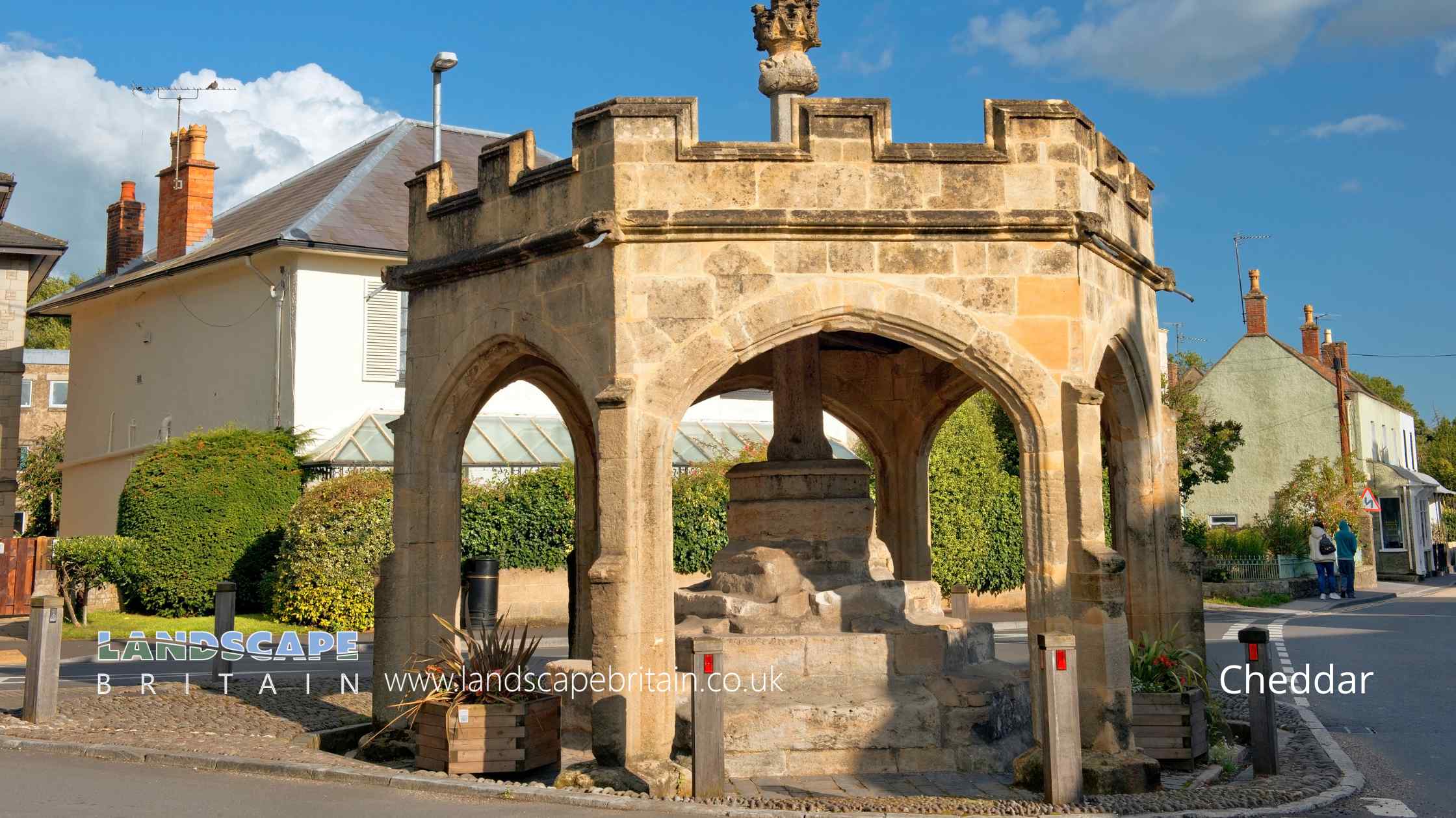
The Market Cross in Cheddar stands as an emblematic landmark, echoing the region’s medieval heritage. Dating back to the 15th century, this historic structure features an ashlar foundation and a central octagonal pier. The socket of the cross is majestically raised on three successive steps and is embraced by a hexagonal shelter. This shelter, rejuvenated in 1834, showcases six beautifully crafted four-centred arch openings. To further accentuate its structural integrity, there are shallow two-stage buttresses at each angle, crowned with an embattled parapet. Though the original cross atop the shaft is absent, an abacus adorned with figures in niches, likely from the late 19th century, graces its zenith.
The Market Cross’s significance and architectural finesse are acknowledged by its Grade II* listed status, a testament to its historical and architectural value. The reconstruction of the shelter in the 19th century was overseen by Thomas, the Marquis of Bath, ensuring the structure retained its venerable charm. As a beacon of Cheddar’s rich past, the Market Cross continues to be a focal point for both locals and visitors alike.
Cheddar Market Cross is in Mendip Hills AONB, a designated Area of Outstanding Natural Beauty.
Created: 11 August 2023 Edited: 29 November 2023
Cheddar Market Cross
Local History around Cheddar Market Cross
There are some historic monuments around including:
Bowl barrow 150m southwest of King Down FarmWestbury Beacon, a bell barrow 720m west of Brimble Pit PoolBowl barrow 590m south-east of Charterhouse Warren FarmGroup of three bowl barrows 180m south of Tyning's Farm: part of the Tyning's Farm round barrow cemeteryBowl barrow 300m north east of Tyning's FarmRowberrow Cavern, Mendip ForestBowl barrow 330m north of Stoke WoodsBowl barrow 350m east of Batts Coombe QuarryAveline's Hole, Burrington CombeBowl barrow 190m south west of Tyning's Farm: part of the Tyning's Farm round barrow cemeteryBowl barrow 900m south west of Bristol Plain Farm: part of a group of round barrows south and south west of Bristol Plain FarmBowl barrow 300m east of Batts Coombe QuarryRoman settlement site, Anglo-Saxon and Norman royal palace, and St Columbanus' ChapelSun Hole, Cheddar GorgeMarket cross at the junction of Bath Street, Union Street and Church StreetBowl barrow 700m south of Bristol Plain Farm: part of a linear round barrow cemeteryRomano-British settlement on Stoke MoorRoman amphitheatre 1/2 mile (800m) N of CharterhouseBowl barrow 430m southwest of King Down FarmCamp 600yds (548m) E of CharterhouseBowl barrow 250m south west of Ashridge FarmBowl barrow 420m north of Stoke WoodsDuck decoy east of Barrow Wood LaneBowl barrow 400m southeast of Wellington FarmGorsey Bigbury earth circle and round barrow near LongwoodWimblestone standing stoneDolebury Camp: a large univallate hillfort and associated and later earthworks on Dolebury WarrenSlight univallate hillfort and associated earthworks on Burrington HamBowl barrow 400m north of Stoke WoodsBlackford Manor House MoatRowberrow Camp: an Iron Age defended settlement north west of Tynings FarmBowl barrow 410m northeast of Bristol Plain FarmWestbury village crossBowl barrow 91m south of Piney Sleight FarmTwin round barrows 750yds (696m) N of Bowpit FarmBowl barrow 420m east of Bristol Plain FarmBowl barrow 820m south of Bristol Plain Farm: part of a linear round barrow cemeterySaye's Hole, Cheddar GorgeDuck decoy 175m south west of Parson's FarmBowl barrow, 540m west of Brimble Pit PoolRoman settlement at Town FieldBowl barrow 550m southwest of NordrachBowl barrow 390m northeast of Bristol Plain FarmWorld War II bombing decoy complex, anti-aircraft obstructions and Beacon Batch round barrow cemetery on Black DownRound barrows 600yds (550m) NW of Longbottom FarmBowl barrow 550m south of Bristol Plain Farm: part of a linear round barrow cemeteryBowl barrow 850m south of Bristol Plain Farm: part of a linear round barrow cemeteryVillage crossEarly Christian settlement and monastic site at Marchey FarmBowl barrow 430m north east of Stoke WoodsManor house at MudgleyBowl barrow 250m south east of Tyning's Farm: part of the Tyning's Farm round barrow cemeteryLongbottom Farm earthworkBowl barrow 870m southwest of Charterhouse Warren FarmBowl barrow 75m south west of Long House BarnCharterhouse lead worksStar Roman villa, 275m north east of WimblestoneDuck decoy, west of Nyland HillCalamine mining remains, south of Glovers FieldGreat Oone's HoleMedieval estate boundary earthwork on Shute Shelve HillBowl barrow 330m east of Batts Coombe QuarryWorld War II anti-aircraft rocket battery and bombing decoy control building 265m north east of Ashridge FarmWestbury Camp, slight univallate hillfort, 750m north of Stokewood CottageGough's Cave, Cheddar GorgeBowl barrow 430m northwest of King Down FarmGough's Old CaveWayside cross at Stoughton CrossBowl barrow, 455m west of Brimble Pit PoolPair of bowl barrows 640m south of Bristol Plain Farm: part of a linear round barrow cemeterySoldier's Hole, Cheddar GorgeBowl barrow 350m northeast of Cheddar Head FarmBowl barrow 340m north-east of Wellington FarmBowl barrow 460m east of Charterhouse Warren FarmDeserted medieval hamlet E of Draycott.


