Castlehowe Stone Circle by munki-boy
Castlehowe Stone Circle
Castlehowe Stone Circle is in The Lake District National Park in England.
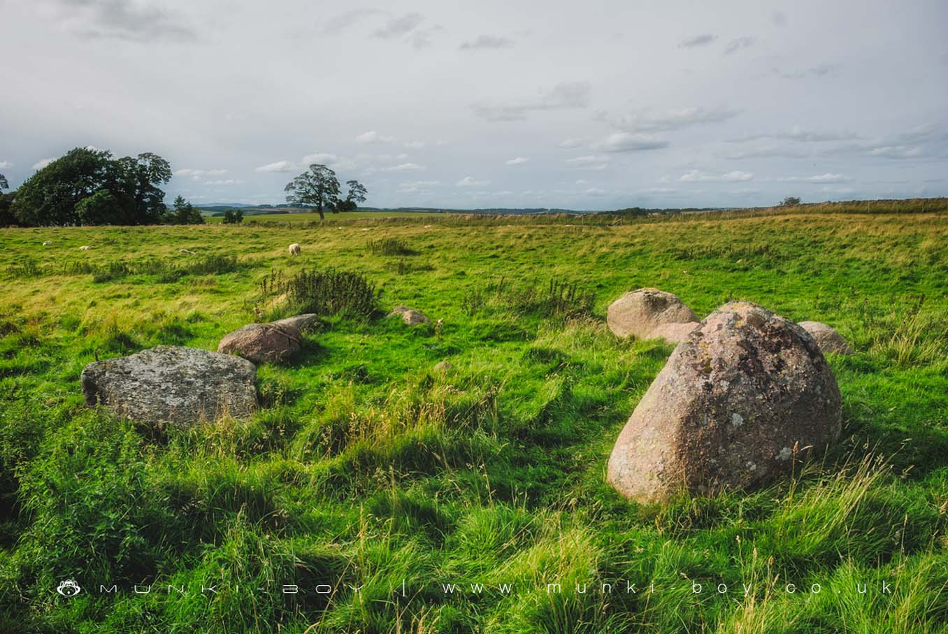
Castlehowe Stone Circle is very small but worth it if you’re monument bagging or passing by on a walk. The circle itself is by the side of a dry stone wall at the edge of a rather lumpy sheep field and doesn’t seem to attract much attention.
The small stone circles such as this one at Castlehowe are usually said to be from the later period of circle building.
Small stone circle 220m south-east of Castlehowe Scar
Castlehowe Stone Circle is a small stone circle located 220m south-east of Castlehowe Scar farm. The monument includes a circle 5m in diameter of 11 variably spaced boulders, 10 of which are rounded pink granite and one being hewn blue granite. The two largest stones are at the southern side of the circle. The westerly of these is hewn blue granite stone and this has fallen. The monument is not known to have been excavated.
Created: 27 November 2016 Edited: 29 November 2023
Castlehowe Stone Circle
Castlehowe Stone Circle LiDAR Map

Contains public sector information licensed under the Open Government Licence v3.0
Local History around Castlehowe Stone Circle
There are some historic monuments around including:
Bowl barrow 40m north-north-east of High HaberSmall stone circle 220m south-east of Castlehowe ScarRound cairn 460m NNE of BroadfellRound cairn 35m east of summit of Long Scar PikeEwe Close Romano-British enclosed and unenclosed stone hut circle settlements and associated field system, medieval farmstead and Wicker Street Roman roadBowl barrow on Iron HillShap large regular stone circleWindrigg Hill round cairn, 440m south of High MurberMedieval shieling south of Cow GreenLyvennet bowl barrowEwe Locks Romano-British settlement, Romano-British farmstead and two medieval shielingsRound cairn 300m west of Lyvennet BeckSkellaw Hill bowl barrowMedieval dyke: part of deer park boundary at Hollins ScarRound cairn on Howenook PikeCrake Trees tower houseShap Premonstratensian Abbey, including the precinct wall, abbey mill and mill race, and two fishpondsOddendale concentric stone circleSmall stone circle on White HagBurwens Romano-British settlement and associated field systemRavens Gill Romano-British farmsteadBowl barrow 20m east of Ravens' GillBowl barrow 230m north-west of GiltsHardendale medieval dispersed settlement and site of medieval monastic grangeCrosby Ravensworth churchyard crossKeld ChapelMedieval dyke: part of deer park boundary south of Cow GreenMedieval dyke: part of deer park boundary on Hazel Moor and two medieval shielingsCow Green long barrowKing's Meaburn medieval settlement, part of its associated medieval open field system and Bessygarth WellMedieval dyke: part of deer park boundary at Cow Green and two medieval shielingsMaulds Meaburn medieval settlement, part of its associated medieval open field system and a mill raceRomano-British settlement and Romano-British farmstead north-east and east of GiltsMedieval dyke: part of deer park boundary west of Cow GreenThree bowl barrows east of Ravens' GillGunnerkeld concentric stone circleRound cairn 320m north-north-west of Seal HoweBowl barrow 70m south of Iron HillMedieval dyke: part of deer park boundary at Crosby GillRound cairn on Dale MoorBowl barrow on Wickerslack MoorHowarcles Romano-British settlementRing cairn north-west of Cattle HoweRomano-British enclosed stone hut circle settlement and associated field system on Wickerslack MoorShap Stone AlignmentCow Green Romano-British settlement and medieval shielingBowl barrow 70m west of Lyvennet BeckMedieval dyke system and shieling west of Shap AbbeyMedieval dyke: part of deer park boundary north of Cow GreenRound cairn 30m east of Wicker Street Roman RoadRound cairn 670m north-east of summit of Long Scar PikeBowl barrow 25m east of Ravens' Gill.