Carl Wark Hillfort by munki-boy
Carl Wark Hillfort
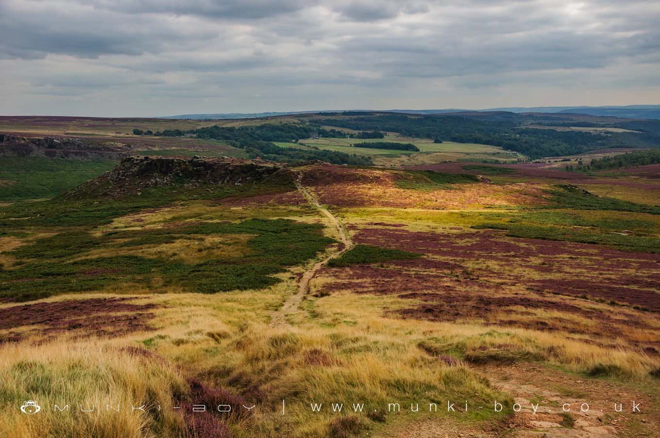
Carl Wark Hillfort is in The Peak District National Park in England.
The site of Carl Wark lies just within the Yorkshire side of the border with Derbyshire, rising out of the boggy centre of the impressive Hathersage Moor, in the Peak District National Park.
There are remains of a drystone revetment wall, on the northwestern end, may date to the Iron Age, still survives over 2 metres in height. It is around 40 metres in length. To the south of it, there is a single interned entrance, which is in a poor state of repair. The whole inner area of the fort covered around 1 hectare.
Carl Wark is of unproven origin, thought to be Iron or Dark age in date, though Bronze age artifacts are also close by, including the remains of a cairn, ring cairn and field systems. It could be that Carl Wark started even earlier, possibly during the Neolithic.
Only a single, small scale excavation has ever been conducted here and it proved to be inconclusive.
Created: 27 November 2016 Edited: 29 November 2023
Carl Wark Hillfort
Carl Wark Hillfort LiDAR Map
please wait...
Contains public sector information licensed under the Open Government Licence v3.0
Local History around Carl Wark Hillfort
There are some historic monuments around including:
Cairnfield, 870m north east of Stanage HouseCairnfield 180m north east of Ramsley LodgeWayside cross west of Fox LaneCamp Green ringworkWayside and boundary cross known as Lady's CrossLead smelting site on Ramsley Moor, 600m south west of Foxlane FarmFroggatt BridgeCarl Wark slight univallate hillfortRing cairn and cairnfield on Eaglestone Flat, 270m east of Eagle StoneCairnfield 630m north east of Stanage HouseWaymarker and clapper bridge 130m south of Barbrook BridgeCairn on Bamford Moor, 960m north east of Clough HouseCairn on Bamford Moor, 500m east of Great TorCairnfield and embanked stone circle 550m east of Barbrook ReservoirHordron Edge stone circle, 540m south east of Cutthroat BridgeMedieval farmstead and field system 525m south of Yarncliff QuarryCairnfield and field system north of Eaglestone Flat, 450m south west of Swine StyMedieval field system and long houses at Lawrence FieldSmall stone circle and central cairn on Eyam Moor, 370m south of Fern CottagePrehistoric landscape on Big Moor and Ramsley MoorCairnfield and associated settlement, 450m south west of Leam Hall FarmThe Warren Romano-British settlement, 320m north west of North Lees HallCairn on Bamford Moor, 850m north west of Crow ChinNewburgh Level at Red Rake MineCairnfield 775m NNE of High Lees FarmPrehistoric standing stone 1,030m south west of triangulation point on High NebCairn on Bamford Edge, 570m north east of Clough HouseCairn 880m south west of Leam Hall FarmWinyards Nick prehistoric field systemCairn on Bamford Moor, 975m north east of Clough HouseCairnfield, 580m ENE of Stanage HouseRound cairn on Curbar EdgeCairn, 600m north east of Stanage HouseEmbanked stone circle known as Wet Withens, and adjacent cairnPadley Hall: a medieval great houseToad's Mouth prehistoric field systemStanage Edge Roman roadMedieval enclosed field system and earlier remains at Sheffield PlantationCairnfield, 320m west of Leam Hall FarmCairn 720m north east of Lady Wash FarmEmbanked stone circle on Eyam Moor, 340m south of Leam Hall FarmWayside cross west of Saltersitch BridgeCairnfield 600m NNE of High Lees FarmCairn 380m south west of Burbage BridgeGrindleford BridgeLead mill on north bank of Bar Brook, 80m east of confluence with Sandyford BrookCairns at Winyards Nick, 680m WSW of Carl Wark HillfortLead smelt mill and wood-drying kiln in Froggatt Wood, 550m south of Haywood FarmAnglian high cross in St Laurence's churchyardCairnfield 970m north west of Green's HouseStoke Flat East prehistoric field systemWayside cross in Shillito WoodCairnfield 320m north of Saltersitch Bridge, Eastern MoorsTwo cairns at Crow ChinRing cairn, 500m north west of Burbage BridgeStone circle, 960m north east of High Lees FarmCalver weir and water management system 200m north east of Stocking FarmStoke Flat West prehistoric field system and stone circleCairnfield and ring cairn 490m south of Offerton HallRing cairn and cairn on Ramsley Moor, 850m north east of Ramsley LodgeTwo ring cairns at Ciceley Low, 500m ESE of Parson House FarmCairnfield, linear clearance and ring cairn 720m north west of Moor Edge FarmNorth Lees ChapelSheepwash Bank and Dennis Knoll prehistoric settlement and field systemCairnfield 600m west of Highlow HallCairnfield 615m west of Moor Edge FarmCairnfield 400m north east of Ramsley LodgeRedmires First World War Training AreaCairn at Winyards Nick 470m south east of Mitchell FieldCairnfield 860m north east of Ramsley LodgeCairn on Bamford Moor, 680m north of High Lees FarmRound cairn on Curbar EdgeStoke Flat South prehistoric field systemCallow prehistoric settlement and field system, Carr Head Moor, 300m ENE of Toothill FarmLead smelting site on Bole Hill, west of Bolehill LodgeStone circle on Ash Cabin Flat, 560m north east of Reservoir Cottages.