Byland Abbey by Hannah Blundell
Byland Abbey
Byland Abbey is in The North York Moors National Park in England.
Byland Abbey is comprised of four separate areas, between which, these contain the standing remains and inner precinct of the Cistercian monastery of St Mary. A variety of associated features including fishponds and other water-management earthworks, quarries, the sites of ancillary buildings, and the remains of monastic enclosures.
Archaeological features relating to the abbey also survive but are insufficiently understood. The extensive standing remains demonstrate the typical layout of a Cistercian monastery.
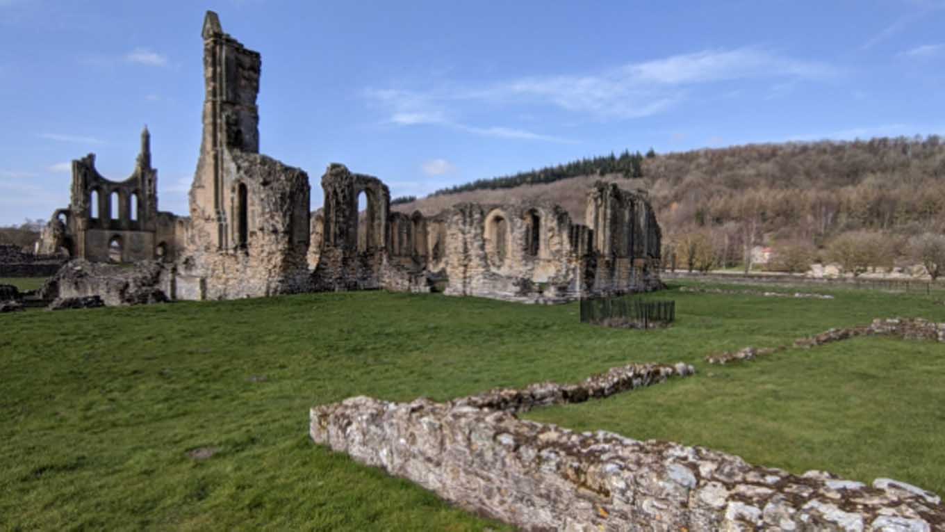
The earliest of the ruins at Byland Abbey are those of the lay-brothers’ quarters, which formed the west range of the cloister. These date to the foundation of the abbey in 1177 and include a reredorter (latrine) and drain as well as the ruins of a vaulted undercroft and the ‘lane’ giving the lay-brothers access to the abbey church.
The church formed the north range of the cloister and is of late Cistercian type, with square end and ambulatory, built in early Gothic style with round-arched windows but pointed vaults; except for parts of the nave, which include the west-front and the remains of its early 13th century wheel window. The church is late twelfth century.
A special feature at Byland is a number of large areas of medieval tiled floor, surviving throughout the church. Building at the abbey appears to have been completed by around 1200 and the only subsequent work was in minor alterations and additions, including that of a meat kitchen in the 15th century. This was built onto the existing south range which consisted of the kitchens, warming-house and frater or refectory.
In the east range were the sacristy, chapter house and parlour, and also the abbot’s lodging, monks’ dorter (dormitory) and reredorter, served by another drain.
Behind the east range lay the monks’ cemetery whilst an infirmary lay to the south. Also standing, 150 metres to the north-west, is the abbey gatehouse. The remains of this consist of a twelfth-century arch which spans the Byland to Oldstead road. A pier on the grass verge north of the road, the remains of a pedestrian archway and an area of collapsed masonry in the field to the north which, although overgrown, is believed to be the site of a room of the gatehouse.
On the south side of the road, a wall runs westward from the main archway and contains a small, well-preserved doorway. This wall is believed to have been the north wall of a porter’s lodge, and, along with the east wall, which is now incorporated into a modern farm building, and survives to a height of 6 metres.
In addition to its standing remains, Byland also possesses a wide range of other features surviving in the modern fields round about. These include parts of the precinct boundary, visible to west and south as a bank containing occasional evidence of walling, and field earthworks, including the enclosure banks of medieval closes.
Byland Abbey was founded in 1177 by the formerly Savignac monks of Old Byland, who had moved to Stocking in 1147 and become Cistercian before moving again to their final location near Wass. The monastery had an uneventful history and was dissolved in 1539 when its lands were granted to Sir William Pickering.
Created: 4 July 2021 Edited: 29 November 2023
Byland Abbey Information
Byland Abbey Address
65, Byland Abbey, York
YO61 4BD
Website: http://www.english-heritage.org.uk/visit/places/byland-abbey/
Get directionsByland Abbey LiDAR Map
please wait...
Contains public sector information licensed under the Open Government Licence v3.0
Local History around Byland Abbey
There are some historic monuments around including:
Griff Cross, wayside cross 800m NNE of Griff Farm on the road from Helmsley to RievaulxRound barrow 230m east of Sutton Bank FarmByland Moor round cairnsRound barrow in Cliff PlantationRound barrow 400m south east of Hill Fort WindypitRound barrow 480m east of Yorkshire Gliding ClubSection of Cleave Dyke, 1.4km long from Sneck Yate Plantation to east edge of Town's Pasture Wood including two pit alignments and round barrowSquare barrow on Scawton Moor, adjacent to the quarry between Snip Gill Slack and Sword Rigg SlackRound barrow 450m north west of Garbutt FarmRound barrow 600m north west of Garbutt FarmRound barrow 810m NNE of Waterloo Farm, the northernmost of three round barrows in Far Moor PlantationTwo round barrows on Yearsley Moor 550m south west of High Lions' LodgeRound barrow 150m north of Wombwell ArmsSection of the Cleave Dyke system near High BarnGriff medieval settlement and Cistercian monastic grange, 400m west of Griff FarmRound barrow 330yds (300m) S of Barhouse FarmNewlass Cistercian monastic grange adjacent to New Leys FarmDouble dykes on Painter RiggPromontory fort at Roulston ScarOld Byland monastic grange immediately to the west and north-west of Valley View FarmRound barrow 780m NNE of Waterloo Farm, the easternmost of three round barrows in Far Moor PlantationLinear dyke known as Double Dikes, in Waterloo PlantationSection of the Cleave Dyke system 200m south east of Yorkshire Gliding ClubDropping Gill round cairnsRound barrow 50m south east of Windyridge FarmDyke at the north eastern end of Stone Bridge Howl, 760m north west of Court House FarmRound barrow on Scawton Moor, 480m north east of High LodgeMedieval lordly residence immediately west of Church FarmRound barrow 650m east of South WoodsRound barrow 600m west of Grange FarmSection of Cleave Dyke prehistoric boundary on Hambleton Down and World War II bombing decoy shelters north east and north of Garbutt FarmFour round barrows on Yearsley Moor 200m south west of High Lions' LodgeSection of the Cleave Dyke system, known as the Casten Dike, 300m ENE of Hambleton InnRound barrow on Sproxton Moor, 410m north of Tom Smith's CrossRound barrow 710m NNE of Waterloo Farm, the southernmost of three round barrows in Far Moor PlantationWayside cross base on south side of the churchyard wall at ScawtonRound barrow 50m east of Windyridge FarmRievaulx Abbey Cistercian monastery: inner and outer precinct, water-management works, agricultural features, enclosures and ancillary buildingsRound barrow on Yearsley Moor 230m SSE of High Lions' LodgeRound barrow on Yearsley Moor 400m south west of High Lions' LodgeWayside cross known as Cooper Cross on Sutton BankSection of the Cleave Dyke system 45m east of the visitors' centre at Sutton BankRound barrow 350m south of Long Plain FarmSection of cross ridge dyke and hollow way 200m north west of Pond Head FarmBoltby Scar promontory fort and two round barrowsRound barrow 500m south east of Hill Fort WindypitStudford RingRound barrow on Scawton Moor, 620m north west of High LodgeRound barrow on Scawton Moor, 390m north east of High LodgeTwo round barrows on Yearsley Moor 260m SSE of High Lions' LodgeRound barrow 350m north west of Pond Head FarmRound barrow 500m WNW of Pond Head FarmTwo sections of the Cleave Dyke system, one known as the Casten Dike, and a round barrow south of Kilburn Moor PlantationPit alignment forming part of the Cleave Dyke system 1000m north west of Dialstone FarmRound barrow on Yearsley Moor 330m SSW of High Lions' LodgeLong Grain round barrowsRound barrow 200m east of High BarnSection of cross ridge dyke and earthworks in Roman Plantation, Oulston MoorTwo round barrows 200m NNE of Wombwell ArmsHood Hill motte and baileyByland Abbey Cistercian monastery: monastic precinct, water-management earthworks, enclosures, ancillary buildings and quarriesRound barrow on Scawton Moor, 700m ENE of High LodgeRound barrow 600m north east of South Woods.


