Brough Castle by munki-boy
Brough Castle
Brough Castle is in The Lake District National Park in England.
Brough Castle dates from around 1100AD and was built to provide protection of routes from the North across land that had only recently been taken from the Scots. Scottish Kings made several attempts to re-capture Cumberland and Westmorland until 1237.
The Gatehouse section of Brough Castle was probably built some time after 1203 when the castle was given to Robert de Vieuxpont.
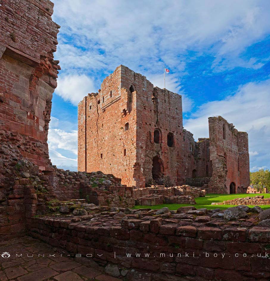
The present Keep was built in the late 12th Century along with other improvements to the castle structure but the castle was described as “decayed” by 1284. The Keep that can be seen today is built on earlier Norman foundations and it is believed that the original structure was composed of stone and wood. The interior of the Keep at Brough Castle has several interesting features that are visible from the ground such as doorways and fireplace settings that were for the upper floors. There is also some remaining structures such as stairs and passageways within the walls that are now inaccessible behind a locked gate.
Some internal passageways still exist within the walls of Brough Castle, in the upper floor areas around the site of the 14th Century Great Hall.
There was a posh double latrine in the North curtain wall of Brough Castle.
There is a garderobe or toilet, still reasonable intact. The garderobe waste chute leads to a hole that can be seen in the outside wall of the castle at ground level.
Built as a residence for Robert Clifford when he took over the castle in 1268, Clifford’s Tower as it is known is notable as it’s structure is markedly less defensive than earlier parts of the castle. Although the walls are still very thick, the addition of windows on all floors that are distinctly stylish, show that the function of the castle was changing from it’s previous defensive purpose. Although the castle was attacked several times by the Scots.
Created: 27 November 2016 Edited: 29 November 2023
Brough Castle
Brough Castle LiDAR Map

Contains public sector information licensed under the Open Government Licence v3.0
Local History around Brough Castle
There are some historic monuments around including:
Swindale Beck prehistoric stone hut circle settlement, associated field system, four ring cairns, a round cairn and three hut platformsRound barrow 1/4 mile (400m) N of Wharton HallGreat Musgrave shrunken medieval villageLynchets WNW of Wharton HallAugill lead smelting mill, later iron roasting plant, associated reservoir, leats, flue and chimney and a Roman signal station immediately E of Augill BridgeRomano-British farmstead and associated trackway 620m south west of Bell NookCroglam Castle defended Iron Age settlementRoman Signal Station, 270m south west of Punchbowl BridgeSwindale Brow prehistoric hut circle settlement, two enclosures and three round cairns, 280m SE of confluence of Swindale Beck and Hilton BeckRomano-British farmstead and medieval field system 100m south west of Bell NookRomano-British farmstead 650m south east of WhingillWhitber Romano-British farmstead 660m south west of Highmore HillWaitby medieval village, part of associated open field system, and site of an associated chapelRomano-British farmstead 670m ESE of WhingillBrough Castle and Brough (Verteris) Roman fort and civil settlementRound barrow 200yds (180m) NE of Hell Gill HowePrehistoric stone hut circle settlement, two associated enclosures and three cairns, 170m west of confluence of Swindale Beck and Hilton BeckWaitby Castle enclosed Romano-British settlement and part of a medieval dykeTwo Romano-British enclosed settlements and an associated regular aggregate field system at Waitby IntakeSettlement N of Hartley QuarriesHowgill Fold Romano-British farmsteadIntake Bottom settlement enclosure and hut circle, 500m WSW of Croglam CastleRomano-British farmstead 700m east of WhingillEastfield Sike medieval moated site, associated fishpond, and medieval woodland boundary banks and ditches at Burtergill Wood and Kiln HillHartley Castle and associated earthworksPrehistoric stone hut circle settlement, an associated field system and two round cairns 700m south west of Great CarrathRookby Scarth medieval settlement.