Barbury Castle
Barbury Castle
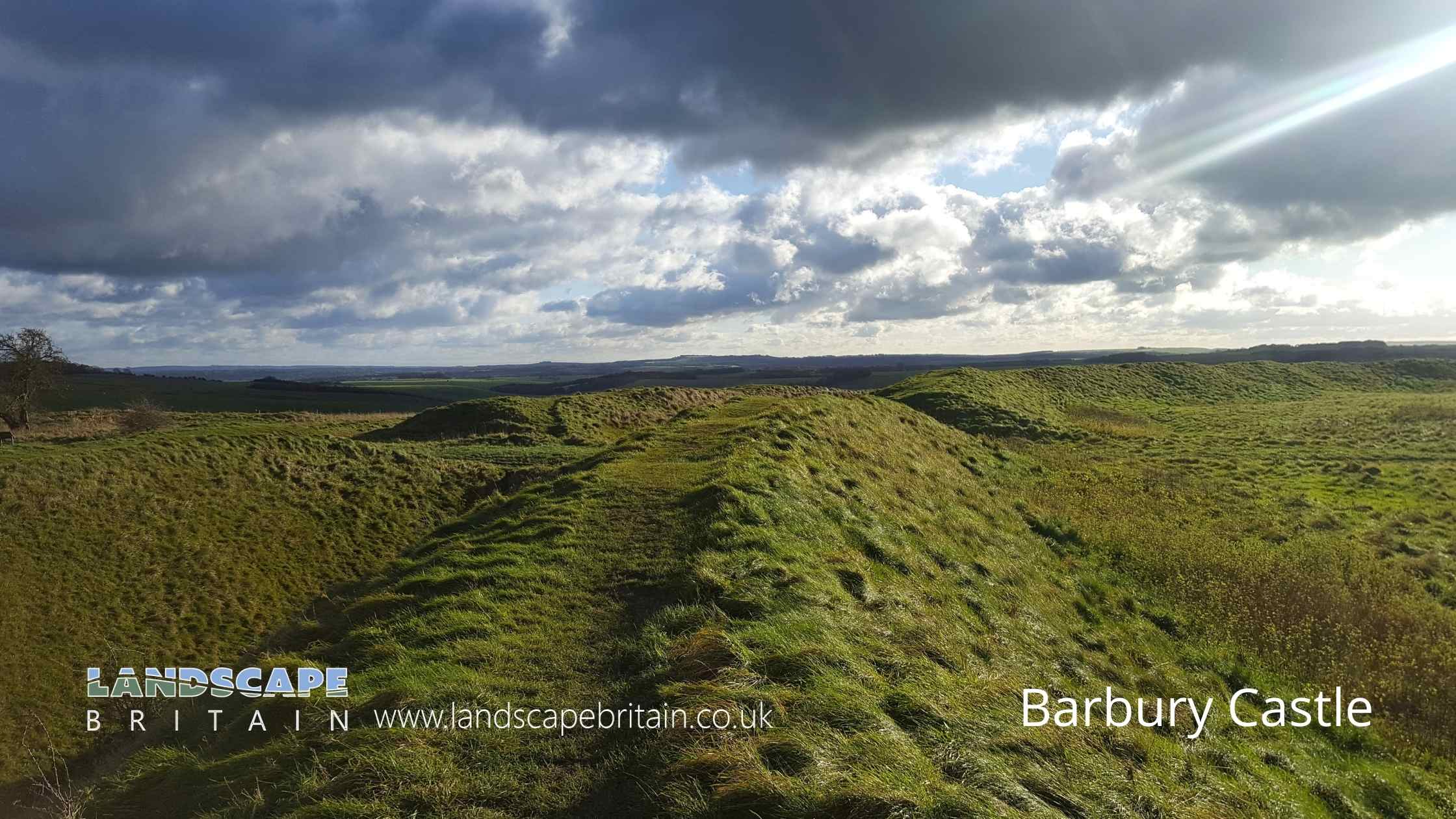
Barbary Castle is an ancient hillfort together with an adjacent bowl barrow.
Hillforts like Barbury Castle are known to have been in use between 600 BC to the middle of the first century CE. Bowl barrows are usually dated between 2400 and 1500 BC, however the barrow here appears to cut into the south escarpment of the hillfort.
The hillfort includes two rings of banks and ditches enclosing an oval area of around 4.5 hectares.
To the north, there is a slight counter-scarp bank which has been much disturbed by quarrying in the past.
There are two original entrances at Barbury Castle, situated to the east and west of the enclosure. A former track running between these follows the parish boundary between Wroughton and Ogbourne St Andrew.
A number of archaeological finds have been made in and around the hillfort over the years and a small scale excavation was carried out in 1875. The finds included an Iron Age blacksmith’s hoard which contained parts of chariot harness furniture, a chariot wheel nave-hoop, sickles, spear heads and other metal work.
Pottery found at Barbury Castle hillfort has been mainly Iron Age and Romano-British.
Barbury Castle was occupied by the United States Army during World War II and has an Ordnance Survey triangulation pillar on the inner rampart, just north of the eastern entrance.
Barbury Castle is in North Wessex Downs AONB, a designated Area of Outstanding Natural Beauty.
Created: 6 August 2022 Edited: 29 November 2023
Barbury Castle
Barbury Castle LiDAR Map

Contains public sector information licensed under the Open Government Licence v3.0
Local History around Barbury Castle
There are some historic monuments around including:
Bowl barrow 750m east of New BarnCross in the churchyard of St John the Baptist and St HelenAvebury henge and stone circlesBarrow 350yds (320m) E of Smeathe's Plantation, Ogbourne DownBowl barrow 650m ESE of New Barn, between Avebury Down and Monkton DownTwo earthwork enclosures and a linear earthwork 625m north of Barbury CastleBowl barrow 800m north-east of Hackpen BarnBarrow on Coombe Down, 930yds (830m) WSW of St George's ChurchStone circle immediately north east of Day House, CoateTwo bowl barrows 680m north of Upper Herdswick Farm, Barbury DownBincknoll CampSaucer barrow 620m north of New Barn: Part of a barrow cemetery on Monkton DownIron Age enclosure on Overton Hill, 600m north west of North FarmCastle moundRound barrow cemetery 400m south of Avebury henge monument on Waden HillBarrow on Smeathe's RidgeSite of watermill 290m south east of West LeazeRemains of `Falkner's Circle', a Neolithic stone circle 180m east of the West Kennet AvenueLinear barrow cemetery on Hackpen HillGroup of four round barrows 500m south-east of Avebury Down Barn, forming part of a Bronze Age round barrow cemetery on Avebury DownBell barrow 300m south-east of Avebury Down Barn forming part of a Bronze Age round barrow cemetery on Avebury DownBowl barrow 620m north of Rockley Manor: part of the Rockley Plantation barrow cemeteryPair of round barrows 400m west of the Ridgeway, forming part of a round barrow cemetery situated on Avebury DownBowl barrow 300m east of Ivy House FarmBowl barrow 690m north of Rockley Manor: part of the Rockley Plantation barrow cemeteryTwo bowl barrows 820m north of Rockley Manor: part of the Rockley Plantation barrow cemeteryBowl barrow 210m north east of Rushy Platt FarmBowl barrow 880m north of Rockley Manor: part of the Rockley Plantation barrow cemeteryBell barrow 350m south-west of Barbury BarnBell barrow 200m north of Rockley PlantationBowl barrow 50m north of Barrow FarmRound barrow 750yds (690m) SE of Smeathe's PlantationBowl barrow 800m south-east of Ogbourne St Andrew FarmBowl barrow 85m north east of Day House CottagesBowl barrow 630m north east of Wick Bottom BarnPair of round barrows forming part of the Bronze Age round barrow cemetery 400m north-east of West Kennett FarmBowl barrow immediately west of the Ridgeway, 400m north east of its junction with Green StreetBowl barrow and a saucer barrow 200m north of Rockley PlantationBowl barrow 800m south-east of Barbury BarnBarrow on Avebury Down, S of track from AveburyThree bowl barrows: part of a barrow cemetery west of Barbury CastleSharpridge field systemBowl barrow 750m north of Rockley Manor: part of the Rockley Plantation barrow cemeterySaucer barrow: part of a barrow cemetery west of Barbury CastleBell barrow and adjacent bowl barrow on Marlborough Common, 120m east of Wootton Bassett RoadGroup of four round barrows 300m north west of the junction between the Ridgeway and Green Street on Avebury DownBarrow on Coombe Down, 1070yds (980m) NE of Upper PoughcombeBowl barrow 1450m south of Barbury Castle FarmBowl barrow 375m east of Wick Bottom BarnBowl barrow 500m west of The RowWick Down Farm earthworkField system and earthwork enclosure on Burderop DownDisc barrow on Burderop Down, 1km north-east of Upper Herdswick FarmSix bowl barrows 560m north of New Barn: part of a barrow cemetery on Monkton DownBarbury Castle Farm deserted Medieval villageMedieval settlement remains at OvertownGreen Bank bowl barrow, 230m east of the Avebury henge monumentBell barrow forming part of a round barrow cemetery 400m north-east of West Kennett Farm on Overton HillSharpridge earthworksOgbourne Maizey Down round barrowBarbury Castle: a hillfort and bowl barrowThree sections of a linear earthwork south west of New BarnPenning bell barrow 600m east of Avebury Down BarnBowl barrow 770m south west of the junction of the Ridgeway and Green Street, forming part of a round barrow cemetery on Avebury DownGroup of round barrows on Rough HillMound in churchyardBowl barrow 900m SSE of Green BankBowl barrow 1km north-east of Avebury and 70m north of Green StreetGroup of six round barrows forming part of a Bronze Age cemetery 400m north-east of West Kennett FarmDevil's Den long barrow, 600m east of White AcreBowl barrow 900m south west of the junction of the Ridgeway and Green Street, forming part of a round barrow cemetery on Avebury DownBowl barrow 70m north of Rockley PlantationPreshute Down field systemEarthwork enclosure and dewpond 490m north of Barbury CastleBowl barrow 750m south-east of Barbury Castle FarmTwo enclosures on Winterbourne DownMedieval settlement and associated ridge and furrow, West LeazeBowl barrow 300m south-east of Walker's PlantationVillage settlement on Barton DownEarthworks on Marlborough CommonDam of King's fishpondEarthwork enclosure 950m SSE of Manor FarmEnclosure on Ogbourne DownBowl barrow 70m north of Green Street and east of the Avebury henge monumentRemains of Holy Rood Church, The Lawn, Old TownBowl barrow 1km west of Sheppard's Farm DairyBowl barrow 500m north-west of Berwick Bassett ClumpThree confluent round barrows 580m west of the Ridgeway, forming part of a Bronze Age round barrow cemetery on Avebury DownBowl barrow 200m south of Green Street and 1100m east of the Avebury henge monument, forming part of a round barrow cemetery on Avebury DownBowl barrow 870m ESE of New Barn on Monkton DownBowl barrow forming part of a Bronze Age cemetery 400m north-east of West Kennett Farm on Overton HillPrehistoric to post-medieval settlement, cultivation, industrial and funerary remains on Fyfield, Overton and Manton Downs.


