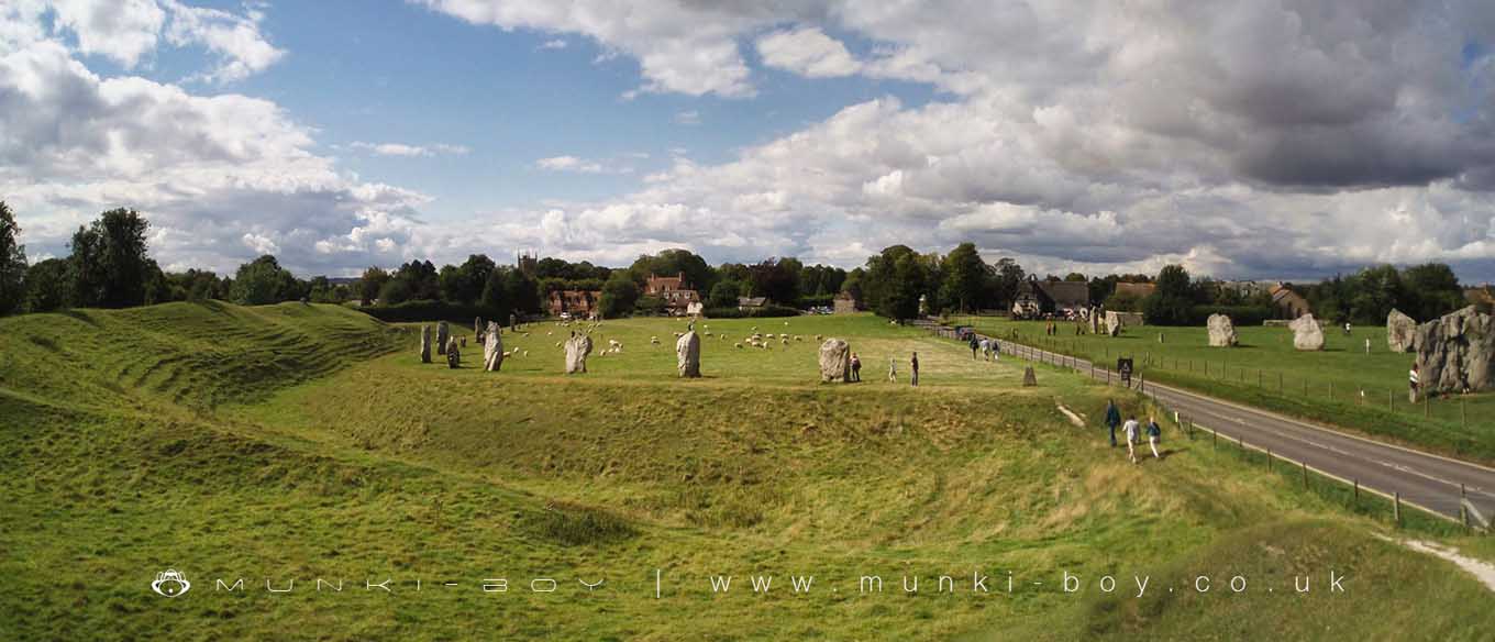
Avebury Henge by munki-boy
Avebury
Avebury in Wiltshire is a small village at the centre of the biggest prehistoric henge monument and stone circle complex in the UK. The village also features a variety of craft shops, bookshops and a museum. There is also the newly refurbished Avebury Manner, a historic stately home.
The village of Avebury is situated in the middle of the UKs largest prehistoric stone circle complex, surrounded by an extensive henge monument and ditch monument. The main stone circles at Avebury were probably constructed around 2500 BC but there is evidence of land use by people for over 6000 years.
Faces in the Avebury Stones
It is a popular tradition to look for the semblance of faces among the twisted forms of the stones at Avebury such as this one. Very many have been spotted and many more are yet to be discovered. There are in fact several popular books available documenting some of the more well-known.
Stones of Avebury
The massive stones of the outer circle at Avebury appear to be placed in order with a roughly rhombus or diamond shaped stone followed by a tall roughly cylindrical stone, alternating around the circle. This has led to supposition that the pattern may be gender related.
Avebury is in North Wessex Downs AONB, a designated Area of Outstanding Natural Beauty.
Created: 27 November 2016 Edited: 29 November 2023
Avebury


Avebury LiDAR Map
please wait...
Contains public sector information licensed under the Open Government Licence v3.0
Local History around Avebury
There are some historic monuments around including:
Bowl barrow 750m south-west of Manor Farm: part of the Windmill Hill round barrow cemeteryBowl barrow 610m south east of Beckhampton Buildings, forming part of a round barrow cemetery on Horton DownBowl barrow forming part of a round barrow cemetery 120m north of the Devizes to Beckhampton road on North DownBowl barrow 750m south west of Beckhampton Buildings forming part of a round barrow cemetery on North DownBell barrow on Easton DownBowl barrow forming part of a round barrow cemetery situated 120m NNW of Down Barn on North DownBowl barrow 300m south of Fox Covert forming part of the Fox Covert round barrow cemetery on West DownPreshute Down field systemThree Bronze Age barrows 200m NNW of Down Barn forming part of a barrow cemetery situated on North DownThree bowl barrows 600m south-west of Knap CottageGroup of four round barrows 500m south-east of Avebury Down Barn, forming part of a Bronze Age round barrow cemetery on Avebury DownBowl barrow 200m east of Windmill Hill: part of the Windmill Hill round barrow cemetery.Pair of bowl barrows situated on the south east of Bishop's Cannings DownPair of round barrows forming part of the Bronze Age round barrow cemetery 400m north-east of West Kennett FarmPair of Bronze Age bowl barrows 400m south west of Beckhampton Buildings, forming part of a cemetery on North DownTwo bowl barrows 320m south-east of Little LondonFour bowl barrows forming part of a cemetery 270m east of long barrow on Roughridge HillLong Stones long barrow 150m north of Beckhampton HouseBowl barrow 770m south west of the junction of the Ridgeway and Green Street, forming part of a round barrow cemetery on Avebury DownBell barrow forming part of a round barrow cemetery on North DownBell barrow 300m south-east of Avebury Down Barn forming part of a Bronze Age round barrow cemetery on Avebury DownBarrow S of WansdykePair of bowl barrows 650m south west of Beckhampton Buildings, forming part of a round barrow cemetery on North DownTwo enclosures on Winterbourne DownBowl barrow 900m SSE of Green BankBowl barrow immediately west of the Ridgeway, 400m north east of its junction with Green StreetBowl barrow 640m south west of Beckhampton Buildings forming part of a round barrow cemetery on North DownField system E of Kitchen Barrow HillEarthwork W of New Town FarmGroup of six round barrows forming part of a Bronze Age cemetery 400m north-east of West Kennett FarmField system 275yds (250m) N of Field BarnBowl barrow 130m SSW of Beckhampton Buildings forming part of a barrow cemetery situated on North DownKnap Hill camp near Alton PriorsBowl barrow 400m west of Cooks PlantationKitchen Barrow: a long barrow on Kitchen Barrow HillBowl barrow 150m north of the Alton White HorseBell barrow situated between Bishop's Cannings Down and Easton DownBowl barrow 200m south of Green Street and 1100m east of the Avebury henge monument, forming part of a round barrow cemetery on Avebury DownBowl barrow forming part of a cemetery 800m east of Kitchen BarrowBowl barrow 1km north-east of Avebury and 70m north of Green StreetDitch W of Tanhill FairSaucer barrow 250m east of Windmill Hill: part of the Windmill Hill round barrow cemeteryEnclosed Iron Age farmstead 450m south of Down Barn on Bishop's Cannings DownRound barrow cemetery and part of a field system 200m south of Beckhampton PenningBowl barrow 870m ESE of New Barn on Monkton DownWinterbourne Bassett moundBowl barrow 350m north-east of White Horse PlantationBowl barrow forming part of a round barrow cemetery on Allington DownLangdean stone circleSaucer barrow on North DownBowl barrow situated 60m west of Beckhampton Buildings forming part of a round barrow cemetery on North DownA causewayed enclosure, the core of a round barrow cemetery, part of a prehistoric field system and an associated mortuary enclosure on Windmill HillSection of Roman Road 560m north east of Beckhampton BuildingsBell barrow 350m south-west of Barbury BarnEnclosure on Horton DownBowl barrow 800m south of Hemp KnollBowl barrow 500m north-west of Berwick Bassett ClumpBowl barrow forming part of a linear round barrow cemetery on Allington DownBarrow on Avebury Down, S of track from AveburyBowl barrow 750m south-east of Windmill HillAll Cannings Cross, an Early Iron Age settlement siteSilbury Hill: a monumental Neolithic mound west of the River Kennet and south of Avebury villageBowl barrow 500m west of The RowGroup of barrows on Draycott HillGroup of five round barrows north-east of the Sanctuary: part of the Overton Hill round barrow cemetery.Medieval settlement, moat and fishponds at Woodhill Park FarmSharpridge field systemEarthwork NW of New Town FarmRound barrow forming part of the Fox Covert round barrow cemetery on West DownBowl barrow forming part of a Bronze Age cemetery 400m north-east of West Kennett Farm on Overton HillThree bell barrows and a pillow mound 400m south-west of Knap CottageBowl barrow east of the Ridgeway forming part of the Overton Hill Bronze Age round barrow cemetery.Bowl barrow 120m west of East Kennett long barrow forming part of a cemeterySaucer barrow 600m west of Beckhampton BuildingsRichardson medieval settlementBowl barrow 50m south-east of the `Sanctuary' forming part of the Overton Hill round barrow cemetery.Four earthwork enclosures on All Cannings DownBowl barrow 800m south-east of Tanhill PenningEarthwork enclosure on Allington DownSection of the WansdykePair of bowl barrows 150m north of the Wansdyke on All Cannings DownBell barrow 600m west of Beckhampton BuildingsPair of round barrows 400m west of the Ridgeway, forming part of a round barrow cemetery situated on Avebury DownBowl barrow 50m north east of East Kennett long barrow forming part of a cemeteryAdam's Grave: a long barrow on Walker's HillTwo bowl barrows 670m south east of Beckhampton Buildings, forming part of a round barrow cemetery on Horton DownLong barrow on Horton DownPair of round barrows 200m SSE of Windmill Hill: part of the Windmill Hill round barrow cemetery.Section of Wansdyke and associated monuments from east of The Firs to the eastern side of Tan HillBowl barrow on Calstone Down, 500m south of Witch PlantationSaucer barrow: part of a barrow cemetery west of Barbury CastleSaucer barrow 620m north of New Barn: Part of a barrow cemetery on Monkton DownSquare enclosure 350m north of Wansdyke on Bishop's Cannings DownShrunken medieval village site E of Avebury TrusloeBowl barrow 40m north west of East Kennett long barrow forming part of a cemeteryPair of bowl barrows on West Down, 550m east of Witch PlantationPair of round barrows and section of linear earthwork NE of the gallops on West DownTwo saucer barrows and a pair of bowl barrows 750m SSW of Beckhampton Plantation, forming part of a round barrow cemetery on Horton DownTen barrows forming part of Fox Covert round barrow cemetery, West Down.Wick Down Farm earthworkBowl barrow 1km west of Tan HillBell barrow 75m west of Red ShoreBowl barrow on Kitchen Barrow HillBeckhampton round barrow cemetery 150m north east of the `Waggon and Horses'Rybury campLinear earthworks forming part of a field system on Bishop's Cannings DownSite of an oval stone circle and part of an adjacent field system 700m SW of West Kennet long barrow.Long barrow and abutting bowl barrow 700m WSW of Beckhampton Buildings, forming the focus of a barrow cemetery on North DownEarthwork enclosure 950m SSE of Manor FarmTwo earthwork enclosures and a linear earthwork 625m north of Barbury CastleStone circleWest Kennett Farm palisaded enclosuresGroup of round barrows on Rough HillGrange bowl barrow 130m north west of The Grange Stables bell barrow, BeckhamptonBowl barrow 200m south of Windmill Hill: part of the Windmill Hill round barrow cemeteryTwo round barrows W of New Town FarmGrange Stables bell barrowBowl barrow in The Belt, 350m north east of Hill BarnBowl barrow 200m north of East Kennett long barrow forming part of a cemeteryLong barrow on Easton DownTwo bell barrows and a bowl barrow forming part of a round barrow cemetery adjacent to the Devizes to Beckhampton road on North DownPair of Bronze Age bowl barrows 200m WSW of Beckhampton Buildings forming part of a barrow cemetery situated on North DownThe Sanctuary, Overton HillBowl barrow 230m west of The Grange, BeckhamptonBarbury Castle: a hillfort and bowl barrowBowl barrow 70m north of Green Street and east of the Avebury henge monumentBowl barrow 375m east of Wick Bottom BarnGroup of four round barrows 300m north west of the junction between the Ridgeway and Green Street on Avebury DownHarepit Way linear boundaryMedieval settlement remains immediately west of The VicarageWest Kennet bell barrow, 160m north-west of West Kennet long barrowAvebury Long Stones 380m east of The Grange Stables, BeckhamptonHorslip long barrow, 450m north-west of Horslip Bridge.Bowl barrow 200m east of East Kennett long barrow forming part of a barrow cemeteryBowl barrow 750m east of New BarnRemains of `Falkner's Circle', a Neolithic stone circle 180m east of the West Kennet AvenueWest Kennet long barrow, 800m south-east of Silbury HillBell barrow 660m south east of Beckhampton Buildings, forming part of a round barrow cemetery on Horton DownBell barrow forming part of a round barrow cemetery 400m north-east of West Kennett Farm on Overton HillFour round barrows 740m east of Kitchen Barrow, forming part of a round barrow cemetery on All Cannings DownBowl barrow 900m south west of the junction of the Ridgeway and Green Street, forming part of a round barrow cemetery on Avebury DownPrehistoric to post-medieval settlement, cultivation, industrial and funerary remains on Fyfield, Overton and Manton DownsBowl barrow forming part of a linear round barrow cemetery on Allington DownBowl barrow 630m north east of Wick Bottom BarnGroup of small enclosures on Horton Down, 910m north east of Easton Down long barrowWest Kennet Avenue and an earthwork bank east of West Kennett FarmWansdyke: section from S of Furze Hill to Marlborough-Pewsey roadBowl barrow 700m south-east of Windmill HillTwo bowl barrows 400m south of Tanhill PenningEarthwork enclosure on Milk HillBowl barrow 950m SSW of Beckhampton Plantation, forming part of a round barrow cemetery on Horton DownSharpridge earthworksThree confluent round barrows 580m west of the Ridgeway, forming part of a Bronze Age round barrow cemetery on Avebury DownThree bowl barrows: part of a barrow cemetery west of Barbury CastleEast Kennett long barrow, 600m south of East Kennett churchEarthwork enclosure N of WansdykeRound barrow cemetery 400m south of Avebury henge monument on Waden HillLinear barrow cemetery on Hackpen HillEarth Burgh (or Eorth Burh) NW of New Town FarmSouth Street long barrow, 70m south east of the Long StonesBowl barrow 300m south-east of Walker's PlantationSix bowl barrows 560m north of New Barn: part of a barrow cemetery on Monkton DownBowl barrow 800m north-east of Hackpen BarnThree Roman burial mounds, a Bronze Age bowl barrow, a pagan Saxon inhumation cemetery and a short length of Roman road on Overton Hill.Pair of bowl barrows forming part of a round barrow cemetery on Allington DownIron Age enclosure on Overton Hill, 600m north west of North FarmBowl barrow 50m south of The Sanctuary on Overton Hill, forming part of the Seven Barrow Hill round barrow cemeteryGreen Bank bowl barrow, 230m east of the Avebury henge monumentThree sections of a linear earthwork south west of New BarnEarthwork enclosure and dewpond 490m north of Barbury CastleAvebury henge and stone circlesBowl barrow 650m ESE of New Barn, between Avebury Down and Monkton DownPenning bell barrow 600m east of Avebury Down BarnBowl barrow 190m north east of Nolands Farm, YatesburyA henge, four Bronze Age barrows and part of a Roman road 500m south west of Fox CovertLinear round barrow cemetery 200m ENE of West Kennett long barrow.