Askham Hall by munki-boy
Askham
Askham is in The Lake District National Park in England.
Askham lies below rolling fells that sweep gently down towards the River Lowther. The far bank, thickly wooded is crowned by the towers and turrets of Lowther Castle, a romantic ruin. There are memorable views from the top of the village over the rooftops to the castle and the distant majesty of the highest Pennine peaks.
There are good walking footpaths leading westwards over the hills to Pooley Bridge and Ullswater.
Askham is built around two greens separated by a central crossroads and buildings which include the 19th-century village school. The lower green beneath scattered trees, is very broad and rises steeply on one side.
Many of the cottages in Askham are of whitewashed stone and date from the 17th century. Near the Queen’s Head, is an arts centre and base for walking tours. The upper has impressive views.
The Church of St Peter at Askham, stands just above the Lowther a short distance from the village and was built in 1832 on the site of an earlier building. Inside is a chapel dedicated to the Sandford family of Askham Hall, who settled in the village in 1373. Parish records in Askham list vicars since the 12th century.
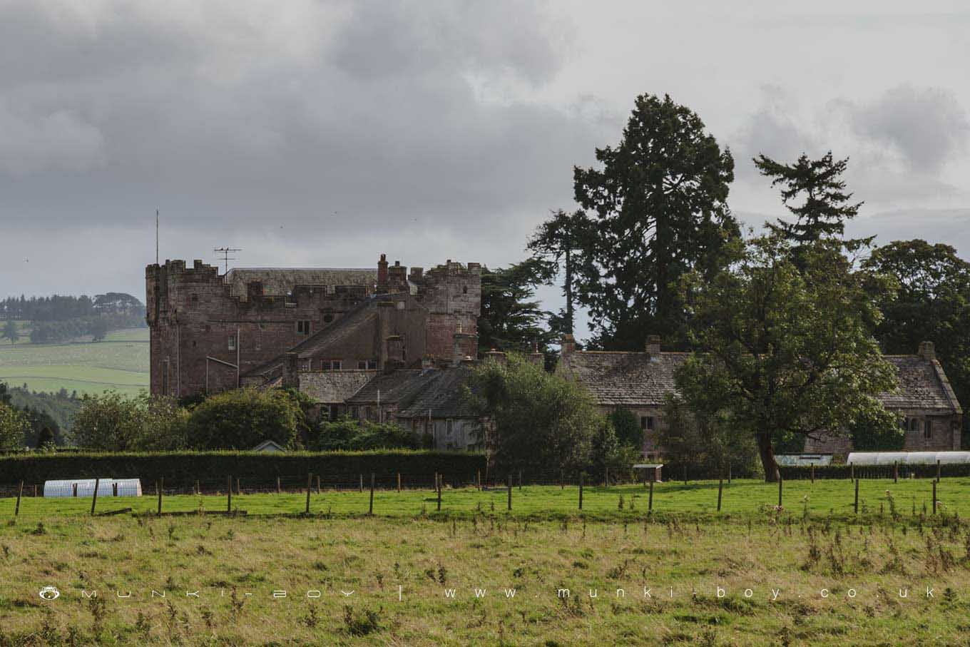
The hall at Askham is set back behind a wall at the foot of the village, was built in medieval times but was substantially altered at the end of the 17th century.
Created: 10 December 2018 Edited: 29 November 2023
Askham


Walks in Askham
Local History around Askham
There are some historic monuments around including:
Round cairn 280m south-east of The Cockpit stone circleWhite Raise round cairn, Askham FellRomano-British settlement and regular aggregate field system north of Yanwath WoodBowl barrow 80m east of Scarside PlantationTowtop Kirk early Christian enclosureThe Cockpit stone circle and seven adjacent clearance cairns, Moor DivockKing Arthur's Round Table hengeThe Old Kiln, Wetheriggs PotteryBridge over Heltondale Beck 250yds (230m) SSW of WidewathRound cairn 580m north east of The Cockpit, Askham FellCastlesteads multivallate prehistoric defended enclosureRing cairn on Askham Fell including The Cop StoneRing cairn east of Threepow RaiseLong barrow on Trainford BrowRound cairn 50m north east of White Raise round cairn, Askham FellStrickland's Pele Tower and Penrith CastleTwo standing stones north-west of Four Stones HillSettlement 1/3 mile (540m) ENE of Brougham CastleRound cairn 490m ENE of Rough Hill TarnLong cairn 370m ESE of Mossthorn FarmThe Giant's Grave - Two Anglian cross-shafts and four hogback stones in St Andrew's churchyard, PenrithClifton Hall towerRoman road and enclosures SE of FrenchfieldRound cairn on Burn BanksSewborrans standing stone 400m south west of SewborwensRound cairn on Heughscar HillRing cairn on Askham Fell and four adjacent stonesMayburgh hengeBowl barrow 850m WSW of Yanwath Woodhouse FarmLong cairn 330m east of MossthornSettlement 100yds (90m) SE of Sceugh FarmRing cairn on Knipescar Common south of Inscar PlantationEamont BridgeAskham Fell stone alignmentRing cairn on Knipescar CommonRound cairn 520m north east of The Cockpit, Askham FellRound cairn 285m south east of White Raise round cairn, Askham FellMoated site and annexe east of Setterahpark WoodBridge over Heltondale Beck 550ft (170m) S of WidewathRound cairn 660m north east of The Cockpit, Askham FellMelkinthorpe medieval settlement, part of its associated open field system and the site of Melkinthorpe HallFour funerary cairns and a surrounding cairnfield on Threepow RaiseLinear stone bank on Askham FellRoman marching camp 450yds (410m) NE of BrovacumBowl barrow 350m north east of The WreaySkirsgill Romano-British enclosed stone hut circle settlement, Romano-British farmstead, and Romano-British regular aggregate field systemRound cairn 490m south east of White Raise round cairn, Askham FellRound cairn 515m south east of White Raise round cairn, Askham FellRound cairn west of enclosure on Four Stones HillRomano-British settlement at Cragside WoodRound cairn west of Riddingleys Top, Askham FellRound cairn on Askham Fell, 335m north of the Cop StoneTwo standing stones and a round cairn south of CrooklandsRomano-British farmstead at HaweswaterRound cairn north of Four Stones HillRound cairn 475m south east of White Raise round cairn, Askham FellBrougham Roman fort (Brocavum) and civil settlement and Brougham CastleStanding stone 180m NNE of SkirsgillEnclosure containing four clearance cairns and a stone bank west of Four Stones HillRound cairn on Askham Fell, 270m north of The Cop StoneMoated site east of Newton ReignyTwo round cairns 415m and 420m NNE of The Cockpit, Moor DivockRound barrow 150m east of Scarside PlantationSlight univallate hillfort in Scarside PlantationThe Countess PillarLittle Round Table hengeThe Giant's Thumb - Anglian high cross in St Andrew's churchyard, PenrithStone bridge, Cawdale BeckRound cairn 680m ENE of Dalefoot.