Llandyssil
Llandyssil is a Village in the county of Powys.
Llandyssil postcode: SY15 6LH
There are great places to visit near Llandyssil including some great waterfalls, mountains, caves and ancient sites.
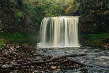
The area around Llandyssil features a number of interesting waterfalls including Sgwd Yr Eira, Dan Yr Ogof Waterfalls, Sgwd Isaf Clun Gwyn, and Sgwd Y Pannwr.
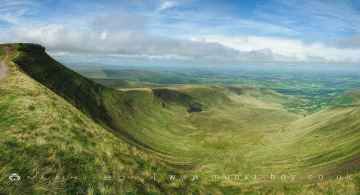
The area around Llandyssil boasts some of the best mountains including Corn Du, and Pen y Fan.
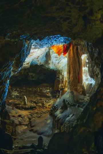
Dan Yr Ogof is a great place to visit close to Llandyssil if you like caves.
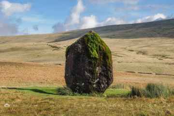
There are a number of ancient sites near to Llandyssil including Maen Llia Standing Stone.
Llandyssil History
There are some historic monuments around Llandyssil:
- Powis Castle Park Mound
- Camp S of Old Hall Sarn
- Ucheldre Camp
- Offa's Dyke: section 400m east of Cwm Farm
- Motte and bailey castle and line of Offa's Dyke adjacent to Brompton Mill
- Great Cloddiau Camp
- Dolforwyn Castle
- Tomen Madoc Castle Mound
- Offa's Dyke: Cwm Section
- Offa's Dyke: section 2/3 mile (1170m) long, N from southern boundary of Rownal Covert
- Lower House Camp
- Motte castle 400m north east of Upper Gwarthlow Farm
- Offa's Dyke: section one mile 750yds (2290m) from Dudston Covert to a point 300yds (274m) N of Lack Brook Also in Powys: Wales
- Camp SW of Great Cloddiau Farm (revealed by aerial photography)
- Offa's Dyke: two sections running 400yds (370m) S of Camlad Stream Also in Powys: Wales
- Montgomery Medieval Town, Kerry Gate Extra Mural Settlement
- Offa's Dyke: section 175m east of Cefn Bronydd
- Offa's Dyke: Section from point 90m S of Chirbury Road to S Boundary of Nant-Cribau Park
- Bowl barrow on Hergan Hill, 530m north west of Myndtown
- Offa's Dyke: Section from Cwm By-Road to Hem Road
- The Lower Short Ditch
- Upper Short Ditch
- Motte castle at the south end of East Dudston hamlet
- Kerry Hill Stone Circle
- Offa's Dyke: section NW of Ditches Farm Also in Powys: Wales
- Cefn Bryntalch Mound & Bailey Castle
- Caer-Din Ring: a small enclosed Iron Age or Romano-British settlement, an adjacent ancient field boundary, round barrow and cultivation remains
- Mound in Churchyard
- Offa's Dyke: Pentre Section
- Camp Pen-y-Gelli (revealed by aerial photography)
- The Moat Mound and Bailey Castle
- Henfron Moated Site
- Trelystan Church House Round Barrows
- Hill Tenement Enclosure
- Fron Derw Wood Camp
- Offa's Dyke: section 400yds (370m) long S of Rownal Covert
- Bowl barrow 1km south east of Hopton Bank
- Plas Yr Alarch Moated Site
- Hen Domen Pre-Conquest Fields
- Offa's Dyke: Section from Road Junction near Drewin to County Boundary
- Dovecote at Chirbury Hall Farm
- Block Wood Round Barrow
- Forden Gaer Roman Site
- Caer Siac Motte and Bailey
- Ffridd Faldwyn Camp
- Montgomery Medieval Town, Part adjacent to Westmead, School Lane
- Coed y Dinas Round Barrow
- Offa's Dyke: Section from Dudston Covert, Lymore to Lack Brook, Churchstoke
- Three Roman camps NW of Brompton Mill including tumulus and section of Offa's Dyke
- Nant-Cribau Castle Mound
- Sibwll Wood Camp
- Maen Beuno
- Offa's Dyke: Section NE of Welshpool-Churchstoke Road
- Bryn-Derwen Mound and Bailey Castle
- Camp 230m SE of Waen Heilyn (revealed by aerial photography)
- Mount Pleasant Enclosure
- Nant-Cribau Moated House Site
- Giant's Bank Camp
- Hen Domen Mound & Bailey Castle
- Offa's Dyke; Brompton Bridge section extending from Brompton Bridge to Mellington Hall Lodge
- Lower Min-y-Llyn Castle Mound
- Small enclosed Iron Age or Romano-British settlement and adjacent cultivation remains, 450m north west of Cwm Farm
- Pen-y-Gaer Camp
- Mound & Bailey Castle
- Montgomery Castle
- Offa's Dyke: Section from North Lodge, Leighton Park to Old Quarry S of Green Wood
- Cefn Llan Hillfort
- Castell Bryn Amlwyg: a ringwork and enclosure castle
- Wantyn Dyke
- Offa's Dyke: section 430yds (390m) in length S of Chirbury-Montgomery road
- Upper Short Ditch Also in Powys: Wales
- Site E of Plas-Llwyn (revealed by aerial photography)
- Town Bank & Ditches
- Offa's Dyke: Section W of Court House Farm
- Ringwork and cultivation remains 260m west of St Michael's Church
- Offa's Dyke: section 1/2 mile (800m) long, SE from county boundary to River Unk Also in Powys: Wales
- Mellington Hill Round Barrow
- Mount in Powis Castle Park
- Cursus, Llwyn-Wron (revealed by aerial photography)
- Offa's Dyke: section 575m north west of Myndtown
- Dyffryn Lane Ring Ditches & Pit Alignments (Formerly Dyffryn Lane Round Barrow)
- Llwynderw Round Barrow
- Offa's Dyke: Section at Pentre Farm
- Pen y Foel Camp
- Camp 270m SSW of Ty Mawr
- Offa's Dyke: section 430m north east of Middle Knuck Farm
- Lower Short Ditch (Northern Part)
- Offa's Dyke: Mellington Hall Section Extending from Mellington Hall Lodge to Lower Cwm
- Blackwood Enclosure
- Site 450m NW of Glan Mule (revealed by aerial photography)