

Ducklington
Ducklington is a Town in the county of Oxfordshire.
There are great places to visit near Ducklington including some great ancient sites, cities and shopping centres.
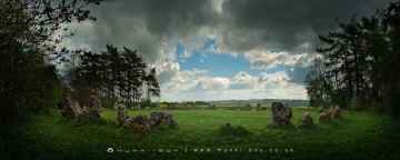
The area around Ducklington features a number of interesting ancient sites including The Rollright Stones, The King Stone, The Whispering Knights, and The Kings Men.
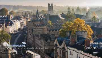
Oxford is a great place to visit close to Ducklington if you like cities.
There are a number of shopping centres near to Ducklington including Westgate Oxford.
Ducklington History
There are some historic monuments around Ducklington:
- Fawler Roman villa
- Section of the north Oxfordshire Grim's Ditch west of Common Farm
- Oaklands Farm Roman villa
- Anglo-Saxon burial mound 450m north west of University Farm
- Minster Lovell Hall
- Barn at Longworth House (hospital)
- 80m section of the north Oxfordshire Grim's Ditch 150m WSW of Ditchley Gate in Blenheim Park
- Leafield Barrow: a motte castle 220m north west of St Michael and All Angels Church
- Long barrow situated in Southlawn Plain Woods
- Slatepits Copse long barrow, 1km SE of High Lodge in Wychwood Forest
- Bowl barrow 200m west of Hawksnest Copse in Wychwood Forest
- Bowl barrow 150m north-west of North Lodge, Cornbury Park
- Asthall Barrow: an Anglo-Saxon burial mound 100m SSW of Barrow Farm
- Site of 19th century pottery factory NW of Leafield
- Pair of Bronze Age bowl barrows situated on Maple Hill in Wychwood Forest
- Pair of Bronze Age bowl barrows 150m north of Roustage Wood
- Pair of bowl barrows at Hawksnest Copse in Wychwood Forest
- Brize's Lodge bowl barrow, 400m east of Gospel Oak
- Long mortuary enclosure and associated barrow 120m south of Rushey Weir
- Burroway enclosure
- Waterman's Lodge bowl barrow, one of a pair of Bronze Age barrows on the western edge of Wychwood Forest
- One of a pair of bowl barrows 370m north-west of High Lodge
- Pair of bowl barrows immediately south of Blindwell Wood
- Causewayed enclosure and associated features on the south bank of the River Thames, immediately west of Rushey Weir
- Civil War artillery fieldwork 370m NNW of Park Farm, Cornbury Park
- Complex of rectangular enclosures, ring ditches and tracks
- Round barrow cemetery 290m east of Old Shifford Farm
- Causewayed enclosure, 900m west of Chimney Farm
- Lew village cross
- New Bridge
- Site of Langley Palace royal hunting lodge, an associated enclosure and later garden earthworks at Langley Farm
- 240m section of the north Oxfordshire Grim's Ditch between Grim's Dyke Farm and the B4437 Charlbury to Woodstock road
- Sites discovered by aerial photography, near Foxley Farm
- Bishop of Winchester's Palace, 90m east of St Mary's Church
- Long barrow 150m west of Churchill Copse in Wychwood Forest
- Roman villa and associated bath house 450m north west of Lower Field Farm
- Earthwork at Lowbarrow Farm
- Bowl barrow 150m east of Waterman's Lodge: one of a pair of Bronze Age barrows on the western edge of Wychwood Forest
- A pair of Roman camps and a section of a post-medieval sunken road situated in the north eastern corner of Cornbury Park
- Stonesfield Roman villa
- Wyke monastic grange and section of 18th century turnpike road, 780m south of Tudor Farm
- The Devil's Quoits
- Rectangular enclosures 1100yds (1010m) NW of Mount Owen Farm
- One of a pair of bowl barrows 370m NW of High Lodge
- Ascott Earl motte and bailey castle
- Prehistoric and later settlements near Northmoor
- North Leigh Roman villa 300m NNE of Upper Riding Farm
- Pair of Bronze Age round barrows and surrounding Civil War fieldworks 180m north-west of Park Farm
- Pair of confluent bowl barrows 200m SSW of Bockett's Corner on Leigh Hale Plain
- Section of the north Oxfordshire Grim's Ditch running east from the River Evenlode opposite Cornbury Park
- Butter cross
- Ring ditches
- 90m section of the north Oxfordshire Grim's Ditch 350m south of Grim's Dyke Farm
- The remains of a medieval moated manor, priory, settlement and associated features, Cogges
- Dovecote 125m north of Minster Lovell Hall
- Medieval moat surrounding High Lodge, 400m north east of Kingstanding Farm
- Great kitchen of manor house
Places to see near Ducklington
Lakes near Ducklington
Canals near Ducklington
Rivers near Ducklington
- Thame upstream of Aylesbury
- Cuttle Brook
- Dorton, Chearsley and Waddesdon Brooks
- Stoke Brook Aylesbury
- Baldon Brook (South of Oxford)
- Holton Brook and tributaries
- Chinor Brook and Sydenham Brook
- Kingsey Cuttle Brook and tributaries at Thame
- Latchford Brook at Tetsworth
- Hardwick Brook (Source to Thame)
- Lewknor Brook
- Thame (Scotsgrove Brook to Thames)
- Scotsgrove Brook (upstream Kingsey Cuttle Brook)
- Peppershill and Shabbington Brooks
- Worminghall Brook and tributaries
- Thame (Aylesbury to Scotsgrove Brook)
- Haseley Brook
- Chalgrove Brook
- Bear Brook and Wendover Brook
- Fleet Marston Brook, Denham Brook, Pitchcott Brook west
- Berrick Stream and Lady Brook
- Wye (High Wycombe fire station to Thames)
- Sulham Brook
- Hamble Brook
- Mill Brook and Bradfords Brook system, Wallingford
- Cholsey Brook and tributaries
- Hughenden Stream
- Ewelme Stream (Source to Thames)
- Ewelme Stream (Source to Thames)
- Thames (Reading to Cookham)
- Wye (Source to High Wycombe fire station)
- Thames Wallingford to Caversham
- Pang
- Letcombe Brook
- Ock and tributaries (Land Brook confluence to Thames)
- Sandford Brook (source to Ock)
- Frilford and Marcham Brook
- Childrey Brook and Norbrook at Common Barn
- Ock (to Cherbury Brook)
- Childrey and Woodhill Brooks
- Stutfield Brook (source to Ock)
- Ginge Brook and Mill Brook
- Thames (Evenlode to Thame)
- Moor Ditch and Ladygrove Ditch
- Northfield Brook (Source to Thames) at Sandford
- Cow Common Brook and Portobello Ditch
- Cherwell (Bletchingdon to Ray)
- Bloxham Brook (Source to Sor Brook)
- Highfurlong Brook (to Cherwell)
- Hanwell Brook
- Tadmarton Stream (Source to Sor Brook)
- Upper Swere (Source to Wigginton)
- Hook Norton Brook (Source to Swere)
- Sor Brook (Broughton to Cherwell)
- Farthinghoe Stream (Source to Cherwell) and tributaries
- Swere (Wigginton to Cherwell)
- Ockley Brook and Croughton Brook (Source to Cherwell)
- Ashby Brook (Source to Cherwell)
- Bayswater Brook
- Deddington Brook (Source to Cherwell)
- Sor Brook (Source to Broughton)
- Cherwell (Ray to Thames) and Woodeaton Brook
- Cherwell (Source to Trafford Bridge)
- Chacombe Brook (Source to Cherwell)
- Cherwell (Ashby Brook to Cropredy)
- Clayton and Wormleighton Brook, Source to Highfurlong Brook
- Cherwell (Cropredy to Nell Bridge)
- Shutford Stream (Source to Sor Brook)
- Cherwell (Nell Bridge to Bletchingdon)
- Littlestock Stream to tributary of Evenlode at Shipton
- Evenlode (Source to Four Shires S) and Longborough Stream
- Glyme (Enstone to Dorn)
- Little Compton Brook and tributaries (Source to Evenlode)
- Evenlode (Bledington to Glyme confluence)
- Glyme (Dorn confluence to Evenlode)
- Evenlode (Compton Bk to Bledington Bk) and 4 Shires
- Heythorpe Stream and tributaries
- Cornwell Brook and tributaries (Source to Evenlode)
- Coldron and Taston Brooks
- Sars Brook (source to Evenlode downstream Bledington)
- Bledington Brook (Source to Evenlode)
- Evenlode (Glyme to Thames)
- Glyme (Source to Enstone)
- Westcote Brook (source to Evenlode at Bledington)
- Dorn (Source to Glyme)


