The Sanctuary by JRL
The Sanctuary
In 1930, the location was re-discovered from Stukeley’s illustrations and the site was excavated. Further excavation, carried out in 1999, revealed a more complex sequence of construction and use than previously thought.
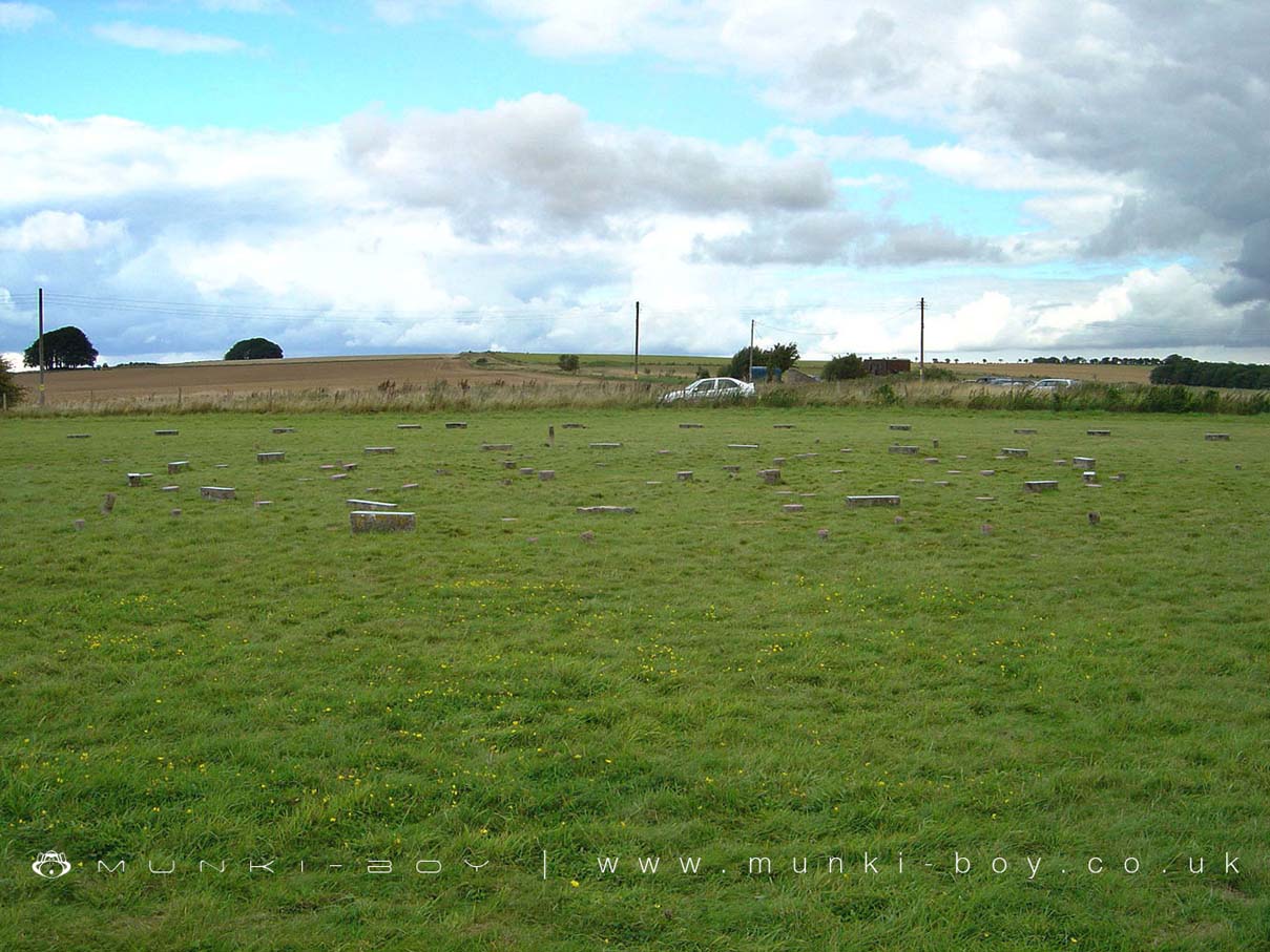
Five thousand years ago a timber shrine was built on this hill. Rebuilt and enlarged several times during the following thousand years, the old shrine was finally replaced by a double stone circle and linked by an avenue of stones to a new temple at Avebury.
The Sanctuary was probably built 4,500 years ago as a ceremonial site. The concrete marker posts show the position of the original stone and wooden posts. It is thought that the wooden posts formed the original monument, but were later replaced by the stones.
The Sanctuary is thought to have been used as a ceremonial site It was connected to the Aveburv stone circle by the West Kennet Avenue, a processional way. The monument was probably in use for about 500 years.
The Sanctuary is in North Wessex Downs AONB, a designated Area of Outstanding Natural Beauty.
Created: 27 November 2016 Edited: 29 November 2023
The Sanctuary
The Sanctuary LiDAR Map

Contains public sector information licensed under the Open Government Licence v3.0
Local History around The Sanctuary
There are some historic monuments around including:
Bowl barrow 230m west of The Grange, BeckhamptonBowl barrow 880m north of Rockley Manor: part of the Rockley Plantation barrow cemeteryBowl barrow 750m east of New BarnBell barrow 200m north of Rockley PlantationThree bell barrows and a pillow mound 400m south-west of Knap CottageBowl barrow 200m south of Green Street and 1100m east of the Avebury henge monument, forming part of a round barrow cemetery on Avebury DownTwo bowl barrows 670m south east of Beckhampton Buildings, forming part of a round barrow cemetery on Horton DownSouth Street long barrow, 70m south east of the Long StonesEarthwork enclosure on Allington DownEarthwork W of New Town FarmWest Kennet long barrow, 800m south-east of Silbury HillWest Kennett Farm palisaded enclosuresThree Roman burial mounds, a Bronze Age bowl barrow, a pagan Saxon inhumation cemetery and a short length of Roman road on Overton Hill.Bowl barrow forming part of a Bronze Age cemetery 400m north-east of West Kennett Farm on Overton HillBowl barrow forming part of a linear round barrow cemetery on Allington DownWick Down Farm earthworkPair of bowl barrows 150m north of the Wansdyke on All Cannings DownGroup of round barrows on Rough HillBowl barrow 690m north of Rockley Manor: part of the Rockley Plantation barrow cemeteryPreshute Down field systemBowl barrow forming part of a round barrow cemetery on Allington DownRound barrow cemetery 400m south of Avebury henge monument on Waden HillRichardson medieval settlementBowl barrow 620m north of Rockley Manor: part of the Rockley Plantation barrow cemeteryPair of round barrows and section of linear earthwork NE of the gallops on West DownBowl barrow 750m south-east of Barbury Castle FarmHarepit Way linear boundaryBowl barrow 800m south-east of Tanhill PenningLong barrow in Barrow CopseSection of Wansdyke and associated monuments from east of The Firs to the eastern side of Tan HillGrange bowl barrow 130m north west of The Grange Stables bell barrow, BeckhamptonBowl barrow 40m north west of East Kennett long barrow forming part of a cemeterySix bowl barrows 560m north of New Barn: part of a barrow cemetery on Monkton DownEarthwork enclosure 950m SSE of Manor FarmThree confluent round barrows 580m west of the Ridgeway, forming part of a Bronze Age round barrow cemetery on Avebury DownGiant's Grave (Martinsell Hill)Langdean stone circleBowl barrow 870m ESE of New Barn on Monkton DownDitch W of Tanhill FairSilbury Hill: a monumental Neolithic mound west of the River Kennet and south of Avebury villageMedieval settlement remains immediately west of The VicaragePair of Bronze Age bowl barrows 200m WSW of Beckhampton Buildings forming part of a barrow cemetery situated on North DownOgbourne Maizey Down round barrowBowl barrow 630m north east of Wick Bottom BarnWansdyke: section from S of Furze Hill to Marlborough-Pewsey roadEarthwork enclosure on Milk HillBowl barrow 750m south-east of Windmill HillEarth Burgh (or Eorth Burh) NW of New Town FarmFour earthwork enclosures on All Cannings DownKnap Hill camp near Alton PriorsBowl barrow 300m east of Ivy House FarmGroup of four round barrows 300m north west of the junction between the Ridgeway and Green Street on Avebury DownBell barrow forming part of a round barrow cemetery 400m north-east of West Kennett Farm on Overton HillShrunken medieval village site E of Avebury TrusloeSite of an oval stone circle and part of an adjacent field system 700m SW of West Kennet long barrow.Bell barrow 350m south-west of Barbury BarnSaucer barrow 250m east of Windmill Hill: part of the Windmill Hill round barrow cemeteryBowl barrow 750m south-west of Manor Farm: part of the Windmill Hill round barrow cemeteryBowl barrow east of the Ridgeway forming part of the Overton Hill Bronze Age round barrow cemetery.Group of six round barrows forming part of a Bronze Age cemetery 400m north-east of West Kennett FarmBowl barrow 500m west of The RowAll Cannings Cross, an Early Iron Age settlement siteBowl barrow 70m north of Rockley PlantationRemains of `Falkner's Circle', a Neolithic stone circle 180m east of the West Kennet AvenueAdam's Grave: a long barrow on Walker's HillHorslip long barrow, 450m north-west of Horslip Bridge.Linear round barrow cemetery 200m ENE of West Kennett long barrowBowl barrow forming part of a linear round barrow cemetery on Allington DownBarrow on Smeathe's RidgeWest Kennet Avenue and an earthwork bank east of West Kennett FarmSharpridge field systemBowl barrow forming part of a cemetery 800m east of Kitchen BarrowGroup of five round barrows north-east of the Sanctuary: part of the Overton Hill round barrow cemetery.A causewayed enclosure, the core of a round barrow cemetery, part of a prehistoric field system and an associated mortuary enclosure on Windmill HillPair of round barrows 200m SSE of Windmill Hill: part of the Windmill Hill round barrow cemetery.Bowl barrow 650m ESE of New Barn, between Avebury Down and Monkton DownAvebury henge and stone circlesRound barrow cemetery and part of a field system 200m south of Beckhampton PenningBowl barrow 770m south west of the junction of the Ridgeway and Green Street, forming part of a round barrow cemetery on Avebury DownThree sections of a linear earthwork south west of New BarnSharpridge earthworksBowl barrow 300m south of Fox Covert forming part of the Fox Covert round barrow cemetery on West DownBowl barrow situated 60m west of Beckhampton Buildings forming part of a round barrow cemetery on North DownGreen Bank bowl barrow, 230m east of the Avebury henge monumentBowl barrow 700m south-east of Windmill HillBowl barrow 300m south-east of Walker's PlantationBowl barrow 50m north of Barrow FarmBowl barrow 50m south-east of the `Sanctuary' forming part of the Overton Hill round barrow cemetery.Barrow on Avebury Down, S of track from AveburyTwo bowl barrows 320m south-east of Little LondonBowl barrow 200m east of East Kennett long barrow forming part of a barrow cemeteryBowl barrow in The Belt, 350m north east of Hill BarnLong barrow on Horton DownBowl barrow 50m south of The Sanctuary on Overton Hill, forming part of the Seven Barrow Hill round barrow cemeteryBowl barrow 900m south west of the junction of the Ridgeway and Green Street, forming part of a round barrow cemetery on Avebury DownLong Stones long barrow 150m north of Beckhampton HouseStone circleBowl barrow 610m south east of Beckhampton Buildings, forming part of a round barrow cemetery on Horton DownAvebury Long Stones 380m east of The Grange Stables, BeckhamptonEnclosure on Horton DownBowl barrow 500m north-west of Berwick Bassett ClumpBowl barrow 950m SSW of Beckhampton Plantation, forming part of a round barrow cemetery on Horton DownBowl barrow 1km north-east of Avebury and 70m north of Green StreetBell barrow 300m south-east of Avebury Down Barn forming part of a Bronze Age round barrow cemetery on Avebury DownBowl barrow 200m east of Windmill Hill: part of the Windmill Hill round barrow cemetery.Bowl barrow 750m north of Rockley Manor: part of the Rockley Plantation barrow cemeteryBarrow S of WansdykeBell barrow 660m south east of Beckhampton Buildings, forming part of a round barrow cemetery on Horton DownSaucer barrow 620m north of New Barn: Part of a barrow cemetery on Monkton DownBell barrow 75m west of Red ShoreBowl barrow 375m east of Wick Bottom BarnBowl barrow 50m north east of East Kennett long barrow forming part of a cemeteryBowl barrow 70m north of Green Street and east of the Avebury henge monumentDevil's Den long barrow, 600m east of White AcreRound barrow forming part of the Fox Covert round barrow cemetery on West DownLinear barrow cemetery on Hackpen HillIron Age enclosure on Overton Hill, 600m north west of North FarmBeckhampton round barrow cemetery 150m north east of the `Waggon and Horses'Bowl barrow 200m north of East Kennett long barrow forming part of a cemeteryTen barrows forming part of Fox Covert round barrow cemetery, West Down.Two saucer barrows and a pair of bowl barrows 750m SSW of Beckhampton Plantation, forming part of a round barrow cemetery on Horton DownGroup of barrows on Draycott HillFour round barrows 740m east of Kitchen Barrow, forming part of a round barrow cemetery on All Cannings DownBowl barrow and a saucer barrow 200m north of Rockley PlantationPair of round barrows forming part of the Bronze Age round barrow cemetery 400m north-east of West Kennett FarmBowl barrow 800m south-east of Barbury BarnWest Kennet bell barrow, 160m north-west of West Kennet long barrowGroup of small enclosures on Horton Down, 910m north east of Easton Down long barrowPrehistoric to post-medieval settlement, cultivation, industrial and funerary remains on Fyfield, Overton and Manton DownsGroup of four round barrows 500m south-east of Avebury Down Barn, forming part of a Bronze Age round barrow cemetery on Avebury DownEarthwork enclosure N of WansdykeField system E of Kitchen Barrow HillA henge, four Bronze Age barrows and part of a Roman road 500m south west of Fox CovertBowl barrow 800m south of Hemp KnollBowl barrow 1450m south of Barbury Castle FarmPair of round barrows 400m west of the Ridgeway, forming part of a round barrow cemetery situated on Avebury DownEast Kennett long barrow, 600m south of East Kennett churchTwo enclosures on Winterbourne DownThree bowl barrows 600m south-west of Knap CottageGrange Stables bell barrowTwo round barrows W of New Town FarmTwo bowl barrows 400m south of Tanhill PenningSection of the WansdykeSection of Roman Road 560m north east of Beckhampton BuildingsBowl barrow 130m SSW of Beckhampton Buildings forming part of a barrow cemetery situated on North DownRybury campPenning bell barrow 600m east of Avebury Down BarnBowl barrow 900m SSE of Green BankPair of bowl barrows forming part of a round barrow cemetery on Allington DownBowl barrow 1km west of Tan HillThe Sanctuary, Overton HillBowl barrow immediately west of the Ridgeway, 400m north east of its junction with Green StreetTwo bowl barrows 820m north of Rockley Manor: part of the Rockley Plantation barrow cemeteryBowl barrow 150m north of the Alton White HorseEarthwork NW of New Town FarmBowl barrow 200m south of Windmill Hill: part of the Windmill Hill round barrow cemeteryBowl barrow 120m west of East Kennett long barrow forming part of a cemeteryWinterbourne Bassett moundBowl barrow 800m north-east of Hackpen Barn.