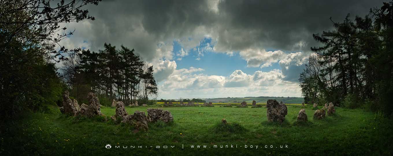
The King's Men stone circle by munki-boy
The Rollright Stones
The names of the three sites which make up the Rollright Stones come from a legend which tells how they were living men, a king and his army. The stones in the circle are The King’s Men, an 8-foot standing stone across the road is The King Stone, and the group of five large stones which once formed a burial chamber and now stand in a huddle in a nearby field are The Whispering Knights.
According to the legend, a witch met the king and his army as they marched across country and she told the king that if, after seven strides, he could see Long Compton, then he should be King of England. Confidently he replied: “Stick, stock, stone, As King of England I shall be known”, but having taken the seven strides, his view of Long Compton was blocked by a mound, known as the Archdruid’s Barrow even though it is natural and not man-made. The witch condemned the king and his men to be forever turned to stone and, somewhat surprisingly, she turned herself into an elder tree.
The Rollright Stones ancient monument
Extract from Record of Scheduled Monuments
The Rollright Stones are a group of excellent ancient stone monuments in close proximity but separated by a modern road that is probably on the site of an older track. The monument is an easy visit with roadside parking, but this means the site can be quite busy.
A small number of areas in southern England appear to have acted as foci for ceremonial and ritual activity during the Neolithic and Early Bronze Age periods. One of the best known and earliest recognised is the Rollright Stones which were first mentioned in the Middle Ages and from the 17th century have been the subject of much speculation and investigation. They were designated as a nationally important monument on the first Schedule of Ancient Monuments in 1882. The monument clearly provided a focus for later activity including an Iron Age settlement, an Anglo-Saxon cemetery and a number of other less well defined remains spanning many periods. The monument includes a stone circle, portal dolmen, standing stone, round cairn and a ditched round barrow which form the core of the megalithic sites known collectively as the Rollright Stones.
Situated 900m north east of Little Rollright on the Oxfordshire - Warwickshire border and which lie within three areas of protection. The monument was one of the 29 monuments protected in the original Schedule for the 1882 Ancient Monuments Protection Act, and was taken into state care in 1883. Although partly obscured by trees and hedges today, the monuments may all originally have been inter-visible. The Rollright Stones lie on the scarp of the Cotswolds on the crest of a ridge running from south west to north east. They have attracted later activity including burial mounds, an Iron Age settlement immediately to the north east (which is the subject of a separate scheduling) and an Anglo-Saxon cemetery. These, taken together, indicate that the area acted as a focus for ritual and burial practice over a long period of time in a similar way to the more famous landscapes around Stonehenge and Avebury in Wiltshire to the south west. The most famous remains are the stone circle known as the ‘King’s Men’ which forms the focus of the monument.
The Dragon Project
In the late 1970’s the Rollright Stones where the focus of a rather romantic project where a series of experiments where to be carried out by ‘scientists’ and members of the New Age community including dowsers and ley-line enthusiasts. The science experiments included measurements of magnetic fields around the old stones, background radiation measurements and ultrasound. Members of the Dragon Project published reports of decreased levels of background radiation within the stone circle and strange ultrasonic emissions from the stones at dawn. The wider scientific community were more skeptical.
The Rollright Stones is in Cotswolds AONB, a designated Area of Outstanding Natural Beauty.
Created: 27 November 2016 Edited: 29 November 2023
The Rollright Stones


The Rollright Stones LiDAR Map

Contains public sector information licensed under the Open Government Licence v3.0
Local History around The Rollright Stones
There are some historic monuments around including:
Moated site 300m east of Stourton Methodist ChapelShrunken medieval village NW of Churchill old churchPortal dolmen 400m south east of Burnt HillThe Rollright StonesChipping Norton motte and bailey castle, and fishpondGreat house site, garden earthworks and associated remains immediately north, west and south of St Mary's ChurchBesbury Lane bowl barrow, 450m north east of Conduit FarmMoated siteChastleton Barrow camp: a hillfort south of Barrow HouseNeolithic long barrow 400m SSE of Burnt HillIron Age enclosed settlement and part of a trackway 150m north east of the King StoneLowland Barn Romano-British farmstead 200m north west of Bury HillMoated site at Manor FarmThe Mount bell barrow 110m south west of Mount FarmLong barrow on Adlestrop HillMoated site, 230m west of St Michael's ChurchSquire's Clump Anglo-Saxon burial mound 500m south west of Iron BuildingsOver Norton bowl barrow 150m north west of the intersection between the A361 and the A34(T)Hawk Stone standing stone 700m south of Claridges Barn.