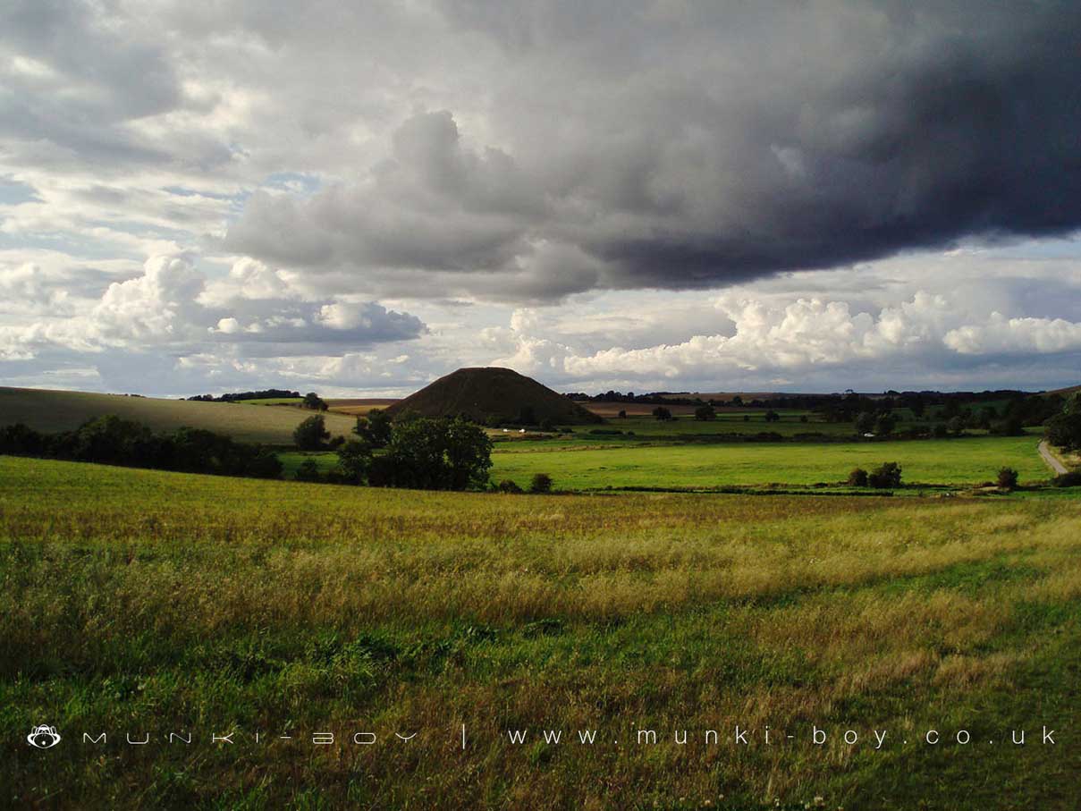
Silbury Hill by munki-boy
Silbury Hill
Silbury Hill is a large, man-made prehistoric mound of unknown purpose. There are many legends about Silbury Hill, one of the more well-known being that there is a life-size gold statue of an ancient king on his horse buried within the mound. Work in recent years required to stabilize the monument confirmed the mound as man-made with some internal structures but sadly, no golden treasure.
Silbury Hill is in North Wessex Downs AONB, a designated Area of Outstanding Natural Beauty.
Created: 27 November 2016 Edited: 29 November 2023
Silbury Hill Details
Silbury Hill is a 187 metre high hill in Wiltshire.
Silbury Hill
Silbury Hill LiDAR Map

Contains public sector information licensed under the Open Government Licence v3.0
Local History around Silbury Hill
There are some historic monuments around including:
Two bowl barrows 670m south east of Beckhampton Buildings, forming part of a round barrow cemetery on Horton DownBowl barrow 300m south of Fox Covert forming part of the Fox Covert round barrow cemetery on West DownWinterbourne Bassett moundBowl barrow forming part of a linear round barrow cemetery on Allington DownCross dyke 520m north east of Cherhill MonumentSaucer barrow 600m west of Beckhampton BuildingsBowl barrow 150m north of the Alton White HorseBowl barrow 350m north-east of White Horse PlantationPreshute Down field systemBowl barrow 200m east of Windmill Hill: part of the Windmill Hill round barrow cemetery.A henge, four Bronze Age barrows and part of a Roman road 500m south west of Fox CovertSection of Wansdyke and associated monuments from east of The Firs to the eastern side of Tan HillPair of Bronze Age bowl barrows 400m south west of Beckhampton Buildings, forming part of a cemetery on North DownRound barrow forming part of the Fox Covert round barrow cemetery on West DownBowl barrow 870m ESE of New Barn on Monkton DownMedieval settlement remains immediately west of The VicarageBowl barrow 610m south east of Beckhampton Buildings, forming part of a round barrow cemetery on Horton DownEarthwork enclosure N of WansdykeLinear barrow cemetery on Hackpen HillBowl barrow 130m SSW of Beckhampton Buildings forming part of a barrow cemetery situated on North DownBowl barrow 300m south-east of Walker's PlantationSaucer barrow on North DownBowl barrow on Calstone Down, 500m south of Witch PlantationPair of bowl barrows 150m north of the Wansdyke on All Cannings DownAvebury henge and stone circlesAvebury Long Stones 380m east of The Grange Stables, BeckhamptonLinear round barrow cemetery 200m ENE of West Kennett long barrowTwo enclosures on Winterbourne DownBowl barrow forming part of a linear round barrow cemetery on Allington DownThree bell barrows and a pillow mound 400m south-west of Knap CottageEnclosed Iron Age farmstead 450m south of Down Barn on Bishop's Cannings DownBell barrow 300m south-east of Avebury Down Barn forming part of a Bronze Age round barrow cemetery on Avebury DownBell barrow 75m west of Red ShoreLangdean stone circleBowl barrow forming part of a Bronze Age cemetery 400m north-east of West Kennett Farm on Overton HillBowl barrow on Kitchen Barrow HillSaucer barrow 620m north of New Barn: Part of a barrow cemetery on Monkton DownSaucer barrow 250m east of Windmill Hill: part of the Windmill Hill round barrow cemeteryBowl barrow 650m ESE of New Barn, between Avebury Down and Monkton DownBowl barrow 230m west of The Grange, BeckhamptonKitchen Barrow: a long barrow on Kitchen Barrow HillEarth Burgh (or Eorth Burh) NW of New Town FarmBowl barrow 770m south west of the junction of the Ridgeway and Green Street, forming part of a round barrow cemetery on Avebury DownWest Kennet long barrow, 800m south-east of Silbury HillLong barrow and abutting bowl barrow 700m WSW of Beckhampton Buildings, forming the focus of a barrow cemetery on North DownBowl barrow forming part of a cemetery 800m east of Kitchen BarrowEast Kennett long barrow, 600m south of East Kennett churchEarthwork enclosure 950m SSE of Manor FarmA causewayed enclosure, the core of a round barrow cemetery, part of a prehistoric field system and an associated mortuary enclosure on Windmill HillBell barrow forming part of a round barrow cemetery on North DownBowl barrow 1km west of Tan HillSite of an oval stone circle and part of an adjacent field system 700m SW of West Kennet long barrow.Earthwork NW of New Town FarmLong barrow on Easton DownRemains of `Falkner's Circle', a Neolithic stone circle 180m east of the West Kennet AvenueTen barrows forming part of Fox Covert round barrow cemetery, West Down.Bowl barrow 900m south west of the junction of the Ridgeway and Green Street, forming part of a round barrow cemetery on Avebury DownBell barrow on Easton DownBowl barrow 1km north-east of Avebury and 70m north of Green StreetBowl barrow 1150m north-east of Baltic FarmEnclosure on Horton DownBarrow S of WansdykeLinear boundary earthwork and associated field system on Cherhill DownWansdyke: section from S of Furze Hill to Marlborough-Pewsey roadWest Kennet bell barrow, 160m north-west of West Kennet long barrowBowl barrow 120m west of East Kennett long barrow forming part of a cemeteryBowl barrow 500m north-west of Berwick Bassett ClumpTwo bowl barrows 320m south-east of Little LondonRound barrow cemetery 400m south of Avebury henge monument on Waden HillPair of bowl barrows on West Down, 550m east of Witch PlantationSilbury Hill: a monumental Neolithic mound west of the River Kennet and south of Avebury villageTwo bowl barrows 400m south of Tanhill PenningGroup of five round barrows north-east of the Sanctuary: part of the Overton Hill round barrow cemetery.Pair of Bronze Age bowl barrows 200m WSW of Beckhampton Buildings forming part of a barrow cemetery situated on North DownThree sections of a linear earthwork south west of New BarnKnap Hill camp near Alton PriorsBowl barrow 640m south west of Beckhampton Buildings forming part of a round barrow cemetery on North DownBowl barrow 750m east of New BarnTwo bell barrows and a bowl barrow forming part of a round barrow cemetery adjacent to the Devizes to Beckhampton road on North DownGrange bowl barrow 130m north west of The Grange Stables bell barrow, BeckhamptonRichardson medieval settlementBell barrow 350m south-west of Barbury BarnPair of round barrows forming part of the Bronze Age round barrow cemetery 400m north-east of West Kennett FarmThree bowl barrows 600m south-west of Knap CottageBowl barrow 750m south-west of Manor Farm: part of the Windmill Hill round barrow cemeteryBowl barrow east of the Ridgeway forming part of the Overton Hill Bronze Age round barrow cemetery.Bowl barrow 750m south-east of Windmill HillAll Cannings Cross, an Early Iron Age settlement siteSouth Street long barrow, 70m south east of the Long StonesBowl barrow 190m north east of Nolands Farm, YatesburyBowl barrow 900m SSE of Green BankBowl barrow 700m south-east of Windmill HillLong barrow on Horton DownBarrow on Avebury Down, S of track from AveburyGroup of four round barrows 500m south-east of Avebury Down Barn, forming part of a Bronze Age round barrow cemetery on Avebury DownWick Down Farm earthworkBowl barrow 200m east of East Kennett long barrow forming part of a barrow cemeteryRybury campGroup of six round barrows forming part of a Bronze Age cemetery 400m north-east of West Kennett FarmBowl barrow 50m north east of East Kennett long barrow forming part of a cemeteryAdam's Grave: a long barrow on Walker's HillBowl barrow 200m north of East Kennett long barrow forming part of a cemeteryBowl barrow 200m south of Windmill Hill: part of the Windmill Hill round barrow cemeteryBowl barrow 800m south of Hemp KnollBowl barrow 950m SSW of Beckhampton Plantation, forming part of a round barrow cemetery on Horton DownBowl barrow 800m north-east of Hackpen BarnEarthwork enclosure on Allington DownShrunken medieval village site E of Avebury TrusloeSharpridge earthworksThree confluent round barrows 580m west of the Ridgeway, forming part of a Bronze Age round barrow cemetery on Avebury DownBowl barrow 400m west of Cooks PlantationBowl barrow forming part of a round barrow cemetery on Allington DownPrehistoric to post-medieval settlement, cultivation, industrial and funerary remains on Fyfield, Overton and Manton DownsBowl barrow 70m north of Green Street and east of the Avebury henge monumentSix bowl barrows 560m north of New Barn: part of a barrow cemetery on Monkton DownGroup of barrows on Draycott HillStone circleTwo saucer barrows and a pair of bowl barrows 750m SSW of Beckhampton Plantation, forming part of a round barrow cemetery on Horton DownGrange Stables bell barrowBowl barrow forming part of a round barrow cemetery 120m north of the Devizes to Beckhampton road on North DownTwo round barrows W of New Town FarmBell barrow 600m west of Beckhampton BuildingsBowl barrow 800m south-east of Tanhill PenningPair of bowl barrows situated on the south east of Bishop's Cannings DownPair of round barrows 400m west of the Ridgeway, forming part of a round barrow cemetery situated on Avebury DownSquare enclosure 350m north of Wansdyke on Bishop's Cannings DownEarthwork W of New Town FarmPair of round barrows 200m SSE of Windmill Hill: part of the Windmill Hill round barrow cemetery.Three Bronze Age barrows 200m NNW of Down Barn forming part of a barrow cemetery situated on North DownPenning bell barrow 600m east of Avebury Down BarnIron Age enclosure on Overton Hill, 600m north west of North FarmBowl barrow 200m south of Green Street and 1100m east of the Avebury henge monument, forming part of a round barrow cemetery on Avebury DownGroup of round barrows on Rough HillDitch W of Tanhill FairGreen Bank bowl barrow, 230m east of the Avebury henge monumentBell barrow 660m south east of Beckhampton Buildings, forming part of a round barrow cemetery on Horton DownBowl barrow in The Belt, 350m north east of Hill BarnBowl barrow forming part of a round barrow cemetery situated 120m NNW of Down Barn on North DownSection of Roman Road 560m north east of Beckhampton BuildingsFour bowl barrows forming part of a cemetery 270m east of long barrow on Roughridge HillBowl barrow 50m south of The Sanctuary on Overton Hill, forming part of the Seven Barrow Hill round barrow cemeteryGroup of small enclosures on Horton Down, 910m north east of Easton Down long barrowBowl barrow immediately west of the Ridgeway, 400m north east of its junction with Green StreetLong Stones long barrow 150m north of Beckhampton HouseThe Sanctuary, Overton HillBowl barrow situated 60m west of Beckhampton Buildings forming part of a round barrow cemetery on North DownBeckhampton round barrow cemetery 150m north east of the `Waggon and Horses'Bowl barrow 1km north-east of Baltic FarmWest Kennet Avenue and an earthwork bank east of West Kennett FarmSection of the WansdykeFour earthwork enclosures on All Cannings DownRound barrow cemetery and part of a field system 200m south of Beckhampton PenningWest Kennett Farm palisaded enclosuresPair of round barrows and section of linear earthwork NE of the gallops on West DownSharpridge field systemEarthwork enclosure on Milk HillHarepit Way linear boundaryLinear earthworks forming part of a field system on Bishop's Cannings DownPair of bowl barrows 650m south west of Beckhampton Buildings, forming part of a round barrow cemetery on North DownThree Roman burial mounds, a Bronze Age bowl barrow, a pagan Saxon inhumation cemetery and a short length of Roman road on Overton Hill.Four round barrows 740m east of Kitchen Barrow, forming part of a round barrow cemetery on All Cannings DownBell barrow situated between Bishop's Cannings Down and Easton DownField system E of Kitchen Barrow HillHorslip long barrow, 450m north-west of Horslip Bridge.Group of four round barrows 300m north west of the junction between the Ridgeway and Green Street on Avebury DownPair of bowl barrows forming part of a round barrow cemetery on Allington DownBowl barrow 40m north west of East Kennett long barrow forming part of a cemeteryBowl barrow 750m south west of Beckhampton Buildings forming part of a round barrow cemetery on North DownBowl barrow 50m south-east of the `Sanctuary' forming part of the Overton Hill round barrow cemetery.Bell barrow forming part of a round barrow cemetery 400m north-east of West Kennett Farm on Overton HillField system 275yds (250m) N of Field Barn.