Bolton Abbey by munki-boy
Bolton Abbey
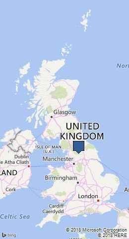
Bolton Abbey is in The Yorkshire Dales National Park in England.
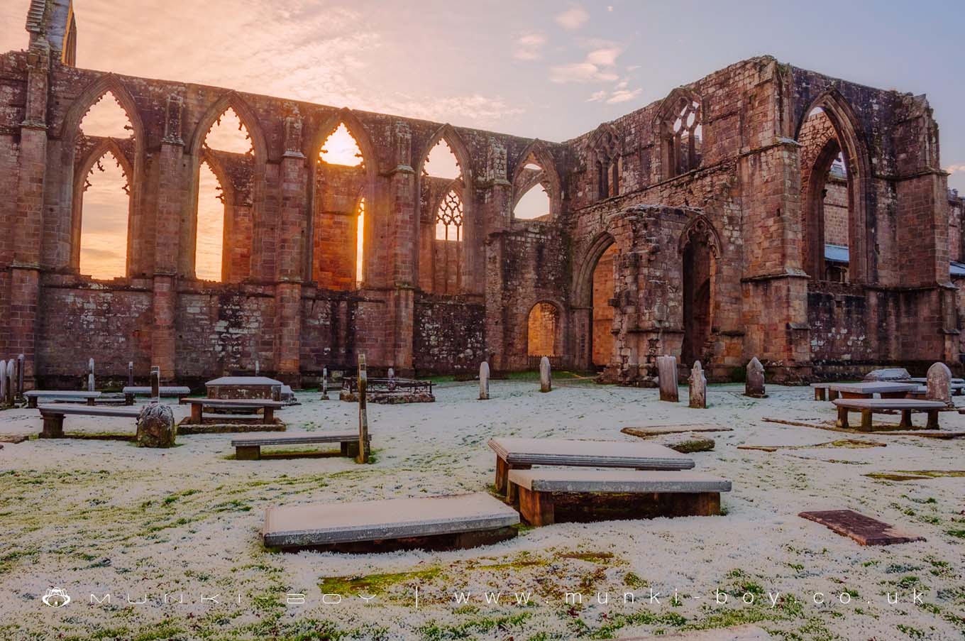
Bolton Abbey is a small village in North Yorkshire situated close to the semi-ruined remains of a 12th Century Augustinian priory which also contains an unruined and functioning Christian church.
The interesting ruins of Bolton Abbey are open to the public and situated on the banks of the River Wharfe surrounded by many walking routes. The old entrance to the abbey is now behind a more recent entrance that leads into the still functioning church. Bolton Abbey features several interesting stone carved figures including a dog-like animal. In addition to the early burials beneath and around the Abbey ruins, there is an old graveyard located behind the Abbey.
Created: 31 August 2016 Edited: 29 November 2023
Bolton Abbey
Bolton Abbey Woodland
Bolton Abbey is a 5.58 hectare, privately owned woodland area in North Yorkshire.Bolton Abbey LiDAR Map

Contains public sector information licensed under the Open Government Licence v3.0
Local History around Bolton Abbey
There are some historic monuments around including:
Large rock with cup marks and cup and ring on Foldshaw Ridge 810m ESE of Wards End, Middleton MoorThree carved rocks near grouse butts on Foldshaw Ridge 870m ESE of Wards End, Middleton MoorRock with seven to eight cup marks north of Dryas Dike 720m ESE of Wards End, Middleton MoorRock with many cup marks on ridge between Dryas Dike and Delves Beck 880m ESE of Blackhill House, Middleton MoorCarved rock known as Pepperpot Rock and adjacent small carved rock west of West Rock and 215m south of White WellsCup and ring marked rock 350m SSW of Panorama ReservoirRock with three cup marks 150m south west of Black Beck HoleTwo cup marked rocks forming part of a group of prominent rocks known as Raven Stones on Rocking Moor, 500m WSW of BraeLarge carved boulder on eminence between two streams east of Barmishaw WellRock with cup marks in south east face near grouse butts on Foldshaw Ridge 860m ESE of Wards End, Middleton MoorCup and groove marked rock near grouse butts on Foldshaw Ridge 905m ESE of Wards End, Middleton MoorCup marked rock between Doubler Stones and Gawk StonesCarved rock in wall of grounds of Overdale Nursing HomeCup, ring and groove marked rock west of the path between Black Hill and Loftshaw Gill, 300m NNE of the shooting shelter in Middleton Moor EnclosureTwo prominent cup marked rock outcrops known as Doubler StonesSite of Roman Fort, Ilkley.Two carved rocks near wall 760m north east of Ridge Lathe, Burhill Kiln Allotment, SkyreholmeCarved rock next to the drive of Overdale Nursing HomeCup marked rock north of track at east end of Foldshaw Ridge, 470m SSE of the shooting shelter in Middleton Moor EnclosureCup marked rock east of entrance to Silver Well CottageProminent rock with one cup mark at apex on ridge between Dryas Dike and Delves Beck 830m ESE of Blackhill House, Middleton MoorRock with a complex pattern of cup, ring and groove marks, 755m NNE of Ridge Lathe, Burhill Kiln Allotment, SkyreholmeRock with at least eight cups and two long grooves on ridge between Dryas Dike and Delves Beck 870m ESE of Blackhill House, Middleton MoorThree carved rocks opposite St Margaret's ChurchBolton PrioryPartially quarried cup and groove marked rock between track and wall at east end of Foldshaw Ridge, 470m south of the shooting shelter, Middleton MoorCup marked rock 39m south east of entrance to Silver Well CottageCup, ring and groove marked rock on south slope of High Black Hill, 350m east of the shooting shelter in Middleton Moor EnclosureCarved rock known as the Anvil RockFive carved rocks grouped between Dryas Dike and Delves Beck 840m ESE of Blackhill House, Middleton MoorRock with one large cup mark on the south slope of High Black Hill, 330m east of the shooting shelter in Middleton Moor EnclosureChurchyard cross at the Church of St PeterRock with many cup marks and one groove between Dryas Dike and Delves Beck 910m ESE of Blackhill House, Middleton MoorRock with one cup mark in track at east end of Foldshaw Ridge, 480m SSE of the shooting shelter in Middleton Moor EnclosureRock with four cup marks near relict walling north of Dryas Dike 710m ESE of Wards End, Middleton MoorRing cairn on Kail Hill 380m north east of High Woodhouse.Rock with at least 30 cup marks, some joined by groove marks, near gate into Larnshaw from Forest Road, 420m north of High Lathe, SkyreholmeCup and ring marked rock known as Piper Crag StoneCup and ring marked rock on moor east of Gawk StonesCup and ring marked rock next to wall NNW of Black PotsCarved rock south east of entrance to Silver Well CottageCarved rock near wall in pasture below Addingham Crag 290m south of Cragg HouseChurchyard cross, BurnsallRound barrow 500ft (150m) NNW of Marchup Plantation in Parson's LaneAnglo-Saxon cemetery and medieval manorial centre including fishponds and part of the open field system adjacent to St Peter's ChurchCup, ring and groove marked rock at east end of the low ridge between Dryas Dike and Delves Beck 980m ESE of Wards End, Middleton MoorTwo carved rocks at the west corner of Raven Stones Plantation on Rocking Moor, 400m west of BraeRock with cup marks and long groove 750m ESE of Blackhill House, Middleton MoorCup marked rock 230m south of and above White WellsCup and groove marked rock on slope south of Delves Beck 870m east of Moor End Farm, Middleton MoorSmall rock with four cup marks and a large hewn rock with one cupmark on Foldshaw Ridge 830m ESE of Wards End, Middleton MoorRock with one cup mark 860m ENE of Wards End, Langbar MoorCup marked rock and small cairn between Dryas Dike and Foldshaw Ridge 730m ESE of Wards End, Middleton MoorCarved rock incorporated in and extending beyond outbuilding at Hardwick House FarmCup and ring marked rock known as the Sepulchre Stone, Addingham MoorsideLow Moor round barrowMedieval settlement and part of the open field system immediately south of Myddleton LodgeRock with at least 24 cup marks, many interconnected by groove marks, 345m north west of High Lathe, Burnetts Ridge, SkyreholmeCup marked rock and cairn near path 775m ESE of Blackhill House, Middleton MoorRock with at least five cup marks and a sinuous groove mark 615m NNE of Ridge Lathe, Pinder Hawes Hill, SkyreholmeRock with a complex design of small cup marks and shallow grooves south of Foldshaw Ridge, 440m south of the shooting shelter, Middleton MoorCairn and carved rock on High Black Hill, 410m ENE of the shooting shelter in Middleton Moor EnclosureCup marked rock on slope, 480m ENE of the shooting shelter in Middleton Moor EnclosureRock with cup marks and short groove 740m ESE of Blackhill House, Middleton MoorRock with seven cup marks enclosed by a groove south of Foldshaw Ridge, 490m south of shooting shelter, Middleton MoorCup and groove marked rock, 310m north east of the shooting shelter in Middleton Moor EnclosureBarden Tower medieval fortified house and medieval garden earthworksCup and ring marked rock known as Langbar Rock 750m ENE of Wards End, Langbar MoorCup and ring marked rock between track and grouse butt north of Dryas Dike, 620m south of the shooting shelter, Middleton MoorCairn on west flank of High Black Hill, 210m ENE of the shooting shelter in Middleton Moor EnclosureRock with at least 13 cup marks 645m NNE of Ridge Lathe, Pinder Hawes Hill, SkyreholmeRecumbent gatepost with cup and ring carving 57m west of the Swastika StoneTwo carved rocks, one dome-shaped and one ridged, near grouse butts on Foldshaw Ridge 880m ESE of Wards End, Middleton MoorRock with two deep cup marks north of track along Foldshaw Ridge, 460m south west of the shooting shelter, Middleton MoorTwo cup marked rocks between Dryas Dike and Delves Beck 810m ESE of Blackhill House, Middleton MoorCup and ring marked rock below Addingham CragOld BridgeRock with at least two cup marks 660m north east of Ridge Lathe, Burhill Kiln Allotment, SkyreholmeRock with three cupmarks west of West Rock and 225m south of White WellsDevil's Apronful cairnFlat carved rock 150m south west of Silver Well CottageCarved rock and two cairns 180m ESE of the shooting shelter, Middleton Moor EnclosureA group of seven carved rocks and four small cairns, south of Eller Edge Nook and 730m ENE of High Lathe, SkyreholmeCarved rock known as the Swastika StoneCup and ring marked rock 370m SSW of Panorama ReservoirRock with at least four large cups and a groove north of Dryas Dike 800m ESE of Wards End, Middleton MoorCarved rock 100m north east of eastern Grainings Head QuarryCup and groove marked rock on flat ground south of Foldshaw Ridge, 510m SSW of the shooting shelter, Middleton MoorThree carved rocks on Long Ridge 420m south east of Wards End, Middleton MoorGroup of four carved rocks in Panorama WoodsLate prehistoric enclosed settlement with an outlying bank and ditch on Counter Hill, 220m north east of Moorcock HallLate prehistoric enclosed settlement known as Round Dykes Camp on Addingham Low MoorCup and ring marked rock between Keighley Gate and Silver Well CottageRound Hill, round barrow 1/2 mile (800m) NNE of Upper Austby FarmCup and ring marked rock between Spicey Gill and the Ilkley-Keighley roadRing cairn 430m south west of Wood EndCup marked rock lying 200m south of and above White WellsRock in Panorama Woods with single cup and ring carving.Wildlife in and around Bolton Abbey
Bolton Abbey Mammals
There are 31 species of mammals recorded as found near Bolton Abbey.
| 45 Khz Pipistrelle (Pipistrellus pipistrellus) |
| Badger (Meles meles) |
| Brown Hare (Lepus europaeus) |
| Chinese Barking Deer (Muntiacus reevesi) |
| Domestic Cat (Felis catus) |
| American Mink (Neovison vison) |
| Bank Vole (Myodes glareolus) |
| Brown Rat (Rattus norvegicus) |
| Common Shrew (Sorex araneus) |
| Fallow Deer (Dama dama) |
Tap here for more wildlife found near Bolton Abbey woodland
Bolton Abbey Birds
There are 167 species of birds recorded as found near Bolton Abbey.
| Bar-Headed Goose (Anser indicus) |
| Black Grouse (Tetrao tetrix) |
| Black-Headed Gull (Chroicocephalus ridibundus) |
| Blackcap (Sylvia atricapilla) |
| Brambling (Fringilla montifringilla) |
| Barn Owl (Tyto alba) |
| Black Tern (Chlidonias niger) |
| Blackbird (Turdus merula) |
| Blue Tit (Cyanistes caeruleus) |
| Bullfinch (Pyrrhula pyrrhula) |
Tap here for more wildlife found near Bolton Abbey woodland